Groundwater is a vital resource, particularly in urban areas where the demand for water is surging due to population growth and industrial activities. A recent study published on March 22, 2025, sheds light on groundwater recharge potential zones (GWPZs) in the Sulaymaniyah Basin of northeastern Iraq. The findings provide essential insights into groundwater management practices, which are increasingly crucial amid changing climate conditions and urban expansion.
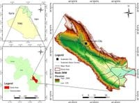
The research employs an innovative combination of geographic information systems (GIS), remote sensing, and multi-criteria decision analysis (MCDA) using the analytical hierarchy process (AHP) to identify potential zones for groundwater recharge. By integrating six thematic layers, comprising rainfall, geology, lineament density, slope, drainage density, and land use, the study delineates three classifications of groundwater recharge potential: low (11.26%), moderate (45.51%), and high (43.23%). This comprehensive mapping initiative is poised to enhance sustainable water resource management strategies in the region.
The Sulaymaniyah basin, covering an area of 1,303 square kilometers, is subjected to a semi-arid climate characterized by average annual rainfall of only 700 millimeters. An alarming decline in groundwater levels has raised significant concerns about water security. The authors of the article state, "One of the most important pillars of water resources management and development is groundwater exploration." This highlights the critical importance of the study in addressing declining groundwater levels driven by urbanization and increased water demand.
To identify groundwater recharge zones more effectively, the research utilizes the AHP method, which ranks the influence of various criteria contributing to groundwater recharge. Notably, rainfall was identified as the most significant factor, with a normalized weight of 0.295, underscoring its critical role in replenishing groundwater resources. Geology, another key parameter, was ranked second, demonstrating the varying impacts of geological formations on groundwater availability.
Lineament density, slope, and drainage density were also assessed. The study revealed that lineaments, or fractures in the Earth's surface, are essential for groundwater flow and recharge, which aligns with previous research indicating their crucial role in groundwater dynamics. Meanwhile, the average slope of the area was found to be about 7%, indicating that gentler slopes can enhance groundwater infiltration due to reduced runoff.
The validation of the GWPZs was conducted using hydrogeological data from 536 wells, along with electrical resistivity tomography (ERT) profiles. This multi-faceted approach produced a solid model with an area under the curve (AUC) accuracy of 86%, as highlighted by the authors: "The results showed that 29% of wells in the high-potential zone had depths less than 100 m, while 49% in the moderate-potential zone had depths between 100 and 200 m." Such data assists policymakers and groundwater managers in directing resources toward areas with the highest potential for sustainable groundwater extraction.
Despite the promising identification of GWPZs, the study acknowledges limitations regarding data availability and suggests that future research should focus on incorporating a wider array of hydrogeological variables. The authors recommend that a multidisciplinary approach, combining advanced geophysical methods and geospatial analysis, will yield more accurate groundwater mapping.
As water shortages become an increasingly pressing global issue, particularly in vulnerable regions, the findings from this study offer a pathway toward more sustainable water resource management strategies. The importance of effective groundwater management resonates with the United Nations' Sustainable Development Goal 6, which aims to ensure availability and sustainable management of water and sanitation for all.
In summary, the integration of geospatial modeling with hydrogeological and geophysical data not only delineates potential groundwater recharge areas but also empowers local stakeholders in the Sulaymaniyah Basin to develop policies that support sustainable water usage and secure future water supplies. This study thus provides a critical tool for managing vital groundwater resources as urbanization and climate change continue to challenge water availability.