After a relatively quiet start to the 2025 Atlantic hurricane season, the tropics have suddenly erupted with activity, putting the Carolinas and the broader southeastern U.S. on high alert. Meteorologists and emergency officials are closely monitoring the development of a tropical system that could soon be named Imelda, as well as the intensifying Hurricane Humberto, both of which are stirring concern for significant weather impacts in the coming days.
On September 26, South Carolina Governor Henry McMaster declared a state of emergency in anticipation of the approaching system. According to ABC News, McMaster’s order activates emergency plans and makes federal assistance available, urging residents to stay vigilant and prepare. "Significant wind, heavy rainfall, and flooding across the ENTIRE state of South Carolina. We have seen this before," the governor stated, emphasizing the unpredictable nature of the storm’s arrival and intensity.
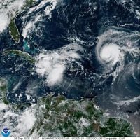
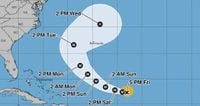
The emerging system, currently known as Potential Tropical Cyclone Nine, is situated over Cuba and the Bahamas. The National Hurricane Center (NHC) has placed a 90 percent probability that it will strengthen into Tropical Storm Imelda within the next 48 hours—a transition expected by September 28. Forecasters warn that, depending on how the system evolves, it could reach hurricane status by Sunday or Monday, possibly making landfall near the South Carolina coast by Monday afternoon or Tuesday.
Flooding is the greatest threat posed by Imelda. The system is expected to interact with a stationary front along the coast, potentially stalling and dumping several days’ worth of rainfall across South Carolina and into Virginia. Damaging winds and storm surge are also possible, with the heaviest impacts forecast from South Carolina to Virginia. Charleston officials are taking no chances—stormwater pumps have been deployed, high-water vehicles are on standby, sandbag distribution plans are underway, and all lakes in the area have been ordered to be lowered. At an emergency city council meeting, Mayor William Cogswell explained, "We have also ordered that all the lakes be lowered," while Chief Fire Marshal Michael Julazadeh added, "Even though this has not formed yet, we are treating it as if we’re expecting some kind of impact. We don’t want to downplay the scenario—we want everybody to begin to prepare."
While Imelda could become a Category 1 or 2 hurricane, a major hurricane (Category 3 or higher) is not expected at this time, according to ABC News. Still, forecasters caution that the track and strength of the storm remain uncertain, and the region should brace for the possibility of significant flooding and wind damage.
Complicating the meteorological picture is Hurricane Humberto, which has rapidly intensified and, as of September 26, is a strong Category 2 hurricane with peak sustained winds of 90 miles per hour. The National Hurricane Center expects Humberto to become the third major hurricane of the 2025 Atlantic season overnight, reaching Category 3 status. Humberto is currently moving west toward the Bahamas but is forecast to veer north toward Bermuda, ultimately staying hundreds of miles away from the U.S. mainland and heading out to sea without making landfall.
Having two powerful storm systems in such close proximity is unusual for the Atlantic, according to meteorologist Alan Gerard, who told Scientific American, "It’s pretty unusual. It’s something you see more often in the West Pacific, where you just have more storms." This rare setup has experts watching for the Fujiwhara effect—a phenomenon where two cyclones within about 850 miles of each other can interact, sometimes orbiting a common point or even merging. Haiyan Jiang, an atmospheric scientist at Florida International University, explained, "They could dance around each other, and if one hurricane is a lot stronger than the other, then the smaller one will orbit around the stronger one and eventually crash into the stronger one. If the two hurricanes are closer in strength, they can just rotate around a common point."
Whether Imelda and Humberto will experience the Fujiwhara effect is still an open question. For now, meteorologists note that the two systems have already interacted, with winds from the developing Imelda system creating wind shear that has affected Humberto’s intensification. This interaction, along with unpredictable atmospheric patterns over the East Coast, has made forecasting especially challenging. Gerard noted, "That certainly will be something that we’ll be watching pretty closely with these two systems."
Adding to the uncertainty is the fact that Imelda does not yet have a clearly defined center of circulation, which is crucial for predicting its path and intensity. As Gerard put it, "Until we get a better handle on that, it’s hard to know which of these scenarios is more likely to occur." Meteorologists are hoping that research flights and additional weather balloon launches over the weekend will provide much-needed data to clarify the situation. "All of that combined should help us get a better picture," Gerard said. "Hopefully, by the end of the weekend, we’ll have a much better expectation of what’s going to happen with all of this."
Meanwhile, the threat of a "predecessor rain event" looms for the Carolinas—a scenario in which heavy rains precede the arrival of a tropical cyclone, leaving the ground saturated and increasing the risk of flooding once the main storm hits. The National Weather Service has already warned of increased risk of rip currents along the North Carolina coast, even as it remains too early to say whether Imelda will directly threaten the Cape Fear region.
The recent uptick in storm activity comes after a lull that saw below-average rainfall in some parts of the Southeast. Corey Davis, North Carolina’s assistant state climatologist, told the USA TODAY Network, "That gives us a reason to expect an uptick in activity over the next few weeks, and it’s worth remembering that hurricane season doesn’t end until Nov. 30." Dr. Michael Mann, a meteorologist at the University of Pennsylvania, added, "We’re currently at seven named storms and a little (12 days) beyond the typical midpoint of the season, activity-wise, so we will likely exceed the long-term average and the total will likely fall within the range we predicted."
Residents are being urged to double-check emergency preparations, as the odds of a storm impacting local areas have increased with the surge in tropical activity. The season’s unpredictability serves as a reminder that it only takes one storm to cause major disruption. As Davis succinctly put it, "You could say we’re stuck between a drought and a wet place."
Amid all this meteorological uncertainty, another threat looms: a potential federal government shutdown on October 1. Gerard expressed concern to Scientific American that such a shutdown could disrupt critical weather data collection and response efforts, particularly if research flights are grounded. "The meteorologists will still be working; the forecasts will still be going out. But there will certainly be additional complications if it’s happening during a shutdown," Gerard warned.
With the tropics heating up and uncertainty swirling, the Carolinas and the broader Southeast are bracing for what could be a volatile and memorable chapter in the 2025 hurricane season. For now, the message from officials and experts alike is clear: stay informed, stay prepared, and keep an eye on the ever-changing skies.