The U.S. East Coast is bracing for a one-two punch from the Atlantic as Tropical Storm Imelda and Hurricane Humberto churn up dangerous weather conditions, threatening millions from Florida to New England and beyond. Over the weekend, meteorologists and emergency officials across the Southeast issued urgent warnings as the tropics grew increasingly active, with both storms set to unleash high surf, coastal flooding, and powerful winds in the coming days.
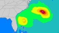
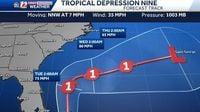
According to the Associated Press, a weather system forecasted to become Tropical Storm Imelda was already causing disruption in the Bahamas and nearby islands early Sunday, September 28, 2025. As of 8 a.m. ET, the storm—still officially designated as Tropical Depression Nine—was centered about 285 miles northwest of Cuba’s eastern tip and 100 miles west-southwest of the Central Bahamas, moving north-northwest at 7 mph. Its maximum sustained winds were measured at 35 mph, but forecasters said it was on track to strengthen into a tropical storm later that day and potentially become a hurricane by late Monday or Tuesday.
This looming threat prompted South Carolina Governor Henry McMaster to urge residents to stay vigilant. "This storm is deadly serious. Not just serious. Deadly serious," McMaster declared at a news conference, emphasizing the potential for high winds, heavy rain, and flooding. The state began prepositioning search and rescue crews over the weekend to ensure a rapid response if needed. North Carolina Governor Josh Stein also declared a state of emergency, a precautionary move as the system’s future path remained uncertain.
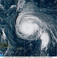
Meanwhile, Hurricane Humberto was making headlines of its own. Having rapidly intensified from a tropical storm to a rare Category 5 hurricane on Saturday, September 27, Humberto slightly weakened but remained a formidable Category 4 storm by Sunday morning. The National Hurricane Center in Miami reported Humberto’s maximum sustained winds at 155 mph, with the storm located about 585 miles south of Bermuda and moving west-northwest at 13 mph. While Humberto was not expected to pose a direct threat to the U.S. mainland, forecasters warned that its influence on the Atlantic would be significant.
The Weather Channel highlighted that both Humberto and the soon-to-be Imelda would churn up the Atlantic, generating large waves and dangerous rip currents along the Eastern Seaboard. Regardless of their exact tracks or intensities, these storms were expected to create days of high surf, hazardous rip currents, and coastal flooding from Florida all the way to New England. In the first half of the week, impacts would be felt most acutely from Florida to the Carolinas, but by the latter part, these conditions would stretch northward, lingering for many days.
"Regardless of the strength of these storms or where they track, there will be days of dangerous surf, rip currents, and coastal flooding next week along the Eastern Seaboard," noted meteorology intern Miriam Guthrie at weather.com. Residents and visitors were urged to stay updated with forecasts as the situation developed.
In the Bahamas, the Department of Meteorology issued tropical storm warnings for the central and northwestern islands, including Nassau, Andros Island, San Salvador, and Long Island. The agency urged residents to "make final preparations" for tropical storm conditions and warned those in low-lying areas to take steps to mitigate property damage from flooding. Rainfall totals between 4 and 12 inches were forecast for the Bahamas and eastern Cuba, raising the risk of flash flooding. Portions of the Bahamas were already under a tropical storm warning, and more advisories were expected as the system progressed.
The storm’s effects were not limited to the Atlantic. In the Pacific, swells generated by Tropical Storm Narda—formerly a hurricane—were affecting coastal Mexico and Baja California Sur, with life-threatening surf and rip current conditions possible as far north as Southern California.
Back in the U.S., preparations ramped up over the weekend. The City of Charleston, South Carolina, declared a local state of emergency on Saturday, September 27, distributing sandbags and clearing storm drains as a proactive measure. Flooding rain remained a concern, especially in the coastal Carolinas, with rainfall totals of 1 to 5 inches forecast through Wednesday morning, October 1. Even as the forecast track for Imelda trended away from a direct landfall along the Southeast coast, officials warned that the storm’s wind field would grow, bringing strong, gusty winds and the potential for storm surge, coastal flooding, and beach erosion.
According to CNN, the path of Tropical Depression Nine (Imelda) had shifted over the previous 24 to 36 hours, with most reliable forecast models now keeping the system offshore of the southeastern United States. Still, the hurricane center cautioned, "While it is too early to feel extremely confident, almost all of the reliable (forecast model) ensembles now keep the system offshore of the southeastern United States, though some impacts are still anticipated." The first effects from the storm were expected as early as Monday, September 29, with coastal areas of eastern Florida, Georgia, and the Carolinas likely to experience the brunt of the impacts. Flooding rain, high surf, and gusty winds remained key concerns.
Humberto, meanwhile, was expected to remain a powerful Category 4 storm into the early part of the work week. While not a direct threat to the U.S., the hurricane could bring bands of rain and gusty winds to Bermuda between Tuesday and Wednesday. Imelda, too, could approach near Bermuda by late in the week, around October 3 to 5, 2025, prompting residents there to keep a close eye on the evolving forecast.
In the Dominican Republic, the precursor disturbance to Imelda brought heavy rains on Friday, September 26, leading authorities to evacuate hundreds and declare a red alert in five provinces. The region was already feeling the storm’s effects days before its potential intensification into a hurricane.
Experts emphasized that the steering pattern between Humberto and a weather system over the Southeast U.S. would likely pull Imelda away from land, but the situation remained dynamic. "The slower than expected northward movement of what is now Tropical Depression Nine means Humberto will win out in a tropical tug-of-war," CNN reported. Residents from the Bahamas to the Southeast coast and Bermuda were advised to monitor updates closely, as the narrow window to prepare could close quickly if the forecast shifted.
Whether or not Imelda makes landfall, the message from officials and meteorologists was clear: the risk from high surf, rip currents, and coastal flooding is real and imminent. As the week unfolds, communities up and down the Eastern Seaboard will be watching the skies—and the waves—hoping for the best but preparing for the worst.
With both storms poised to leave their mark, the next several days will test the readiness and resilience of coastal communities from the Caribbean to New England.