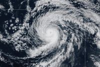
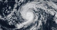
Hurricane Kiko, a formidable storm that’s been churning across the central Pacific, is now weakening as it approaches Hawaii, offering a measure of relief to islanders who have been warily tracking its every move. Over the past week, Kiko’s unpredictable path and fluctuating intensity have kept meteorologists and residents alike on high alert, but recent forecasts suggest that the worst-case scenario—a direct landfall—will likely be avoided. Still, the islands aren’t entirely out of harm’s way, as dangerous surf and rip currents threaten to impact east-facing shores through midweek.
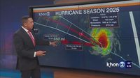
On Sunday, September 7, 2025, the National Hurricane Center in Miami reported that Hurricane Kiko was about 635 miles east of Hilo on the Big Island, moving west-northwest at 13 mph. The storm’s maximum sustained winds stood at 110 mph, down from 120 mph the previous day. By Sunday evening, Kiko had weakened further, dropping from a Category 3 to a Category 2 hurricane with sustained winds of 105 mph and was 555 miles east of Hilo, according to the center’s 11 p.m. ET update. The hurricane was heading northwest at 14 mph, continuing its gradual journey towards the Hawaiian archipelago.
Kiko’s recent history has been a rollercoaster. As reported by multiple outlets, the storm intensified into a Category 1 hurricane in the eastern Pacific last week, rapidly strengthening to a Category 4 before beginning its downward trajectory. The National Hurricane Center now expects Kiko to weaken further, likely becoming a tropical storm by late Monday, September 8, 2025, as it tracks north of the islands.
Despite the storm’s decreasing intensity, the National Hurricane Center has cautioned that the threat of hazardous surf remains very real. Swells generated by Kiko are forecast to build steadily, peaking along east-facing exposures of the Hawaiian Islands late Monday through midweek. The center warned that these conditions could produce life-threatening surf and rip currents, with waves expected to reach between 10 and 15 feet (3 to 4.5 meters) in some places. As a result, residents and tourists alike are being urged to exercise extreme caution along the coasts, particularly on beaches exposed to the east.
“Swells generated by Kiko will gradually build and are forecast to peak along east-facing exposures of the Hawaiian Islands late Monday through midweek, potentially producing life-threatening surf and rip currents,” the National Hurricane Center stated in its latest advisory. While no formal hurricane watches or warnings have been issued for Hawaii as of September 7, 2025, officials emphasize the importance of staying informed as conditions can change rapidly in the Pacific.
The storm’s path is now expected to steer north of the main Hawaiian Islands on Tuesday and Wednesday, September 9 and 10, 2025. This track significantly reduces the risk of direct impacts—such as damaging winds and torrential rain—on the islands themselves. However, forecasters are quick to note that the situation remains fluid, and interests in Hawaii should continue to monitor official updates.
On the ground, the atmosphere has already begun to shift in anticipation of Kiko’s approach. According to KHON2, dry conditions spread across Hawaii on Monday morning, with only a few lingering showers near Kauai and Oahu. But as the day progresses, moisture along the western flank of the weakening hurricane is expected to near the windward coasts of the Big Island and Maui. This will likely result in an uptick in clouds and windward showers by Monday night and Tuesday, with the possibility of brief but locally heavy thunderstorms as the atmosphere destabilizes. Dew points are forecast to creep into the low to mid 70s Fahrenheit, ushering in a spell of rather humid weather.
As Kiko’s influence wanes and the storm moves off to the northwest of the state by Wednesday night and Thursday, meteorologists expect a return to more stable and drier conditions. A ridge aloft and moderate trade winds should build in from the east, bringing back the typical pattern of windward rainfall and lower dew points—more comfortable weather for islanders accustomed to the tropics.
Despite the diminished threat of a direct hit, the psychological toll of tracking a major hurricane is not lost on the community. Hawaii’s unique geography means that even storms passing at a distance can have outsized effects, especially when it comes to surf and coastal hazards. The National Hurricane Center’s repeated advisories underscore this point, urging residents to keep a close eye on the latest forecasts and heed all safety recommendations.
“The risks of direct impacts on the islands appeared to be decreasing but it urged people in the islands to continue monitoring the storm’s progress,” the National Hurricane Center emphasized, highlighting the unpredictable nature of these powerful systems.
For many in Hawaii, the threat of hurricanes is a familiar, if unwelcome, part of life during the late summer and early fall. The Pacific hurricane season typically runs from June through November, and while the islands are shielded by vast stretches of open ocean, their isolation can make them particularly vulnerable to storms that manage to steer their way. Over the years, Hawaii has experienced its share of close calls and direct hits, from Hurricane Iniki in 1992 to more recent brushes with storms that brought heavy rain, flooding, and wind damage.
This time, though, the consensus among forecasters is that Kiko will spare the islands the worst of its wrath. The absence of coastal watches or warnings as of September 7, 2025, is a testament to the storm’s shifting trajectory and weakening core. Still, the lessons of past hurricanes linger, prompting officials to err on the side of caution and maintain a vigilant posture until Kiko is well clear of the region.
As the week unfolds, all eyes will remain on the surf and skies, with local authorities and meteorologists providing regular updates to ensure the safety of residents and visitors alike. Whether it’s a day at the beach or a quiet evening at home, the people of Hawaii know all too well that nature’s power is never to be underestimated—even when a hurricane seems to be losing steam.
With Kiko’s center expected to pass north of the main islands and conditions set to stabilize by midweek, the mood across Hawaii is one of cautious optimism. The coming days will bring a mix of humid air, spotty showers, and—most notably—impressive waves crashing ashore. For now, the islands are breathing a little easier, grateful that this hurricane’s bark appears to be worse than its bite.