Two powerful storms swirling in the Pacific—Hurricane Kiko and Tropical Storm Lorena—are commanding the attention of meteorologists and residents from Mexico’s Baja California Peninsula to the U.S. Southwest and beyond. Both storms have taken unpredictable turns, threatening to unleash heavy rain, flash flooding, and hazardous surf conditions across a vast region as the first week of September 2025 draws to a close.
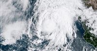
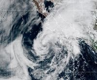
On Thursday, September 4, 2025, the U.S. National Hurricane Center announced that Hurricane Lorena, after briefly reaching Category 1 status with maximum sustained winds of 80 mph, had weakened back to a tropical storm as it churned about 105 miles west-southwest of Cabo San Lazaro, Mexico. According to the National Hurricane Center, Lorena was moving northwest at 8 mph and was expected to continue losing strength as it encountered cooler waters and dry air. Still, the threat posed by Lorena was far from over. Heavy rainfall—potentially reaching up to 15 inches in some parts of Baja California Sur, Baja California, and Sonora—was forecast through Friday, raising the specter of flash floods and dangerous mudslides in western Mexico.
According to AccuWeather, a tropical storm warning was in effect for the west coast of Baja California Sur from El Conejo to Punta Eugenia. "Lorena will bring heavy rain and strong winds to southern Baja California through the end of the week, which could lead to life-threatening flooding and widespread power outages," warned AccuWeather Lead Hurricane Expert Alex DaSilva. The hardest-hit areas were expected to include Cabo San Lucas, San José del Cabo, La Paz, and San Carlos, with conditions worsening farther north into Santa Rosalia and Hermosillo as the weekend approached.
As Lorena’s center struggled to maintain its structure, forecasts suggested the storm would likely stall off the coast of Baja California and dissipate over the weekend, rather than making a direct landfall. But even without a dramatic landfall, Lorena’s remnant moisture posed a significant threat. Meteorologists at expressnews.com noted that, while Lorena could not make landfall in Texas due to its Pacific track, its moisture was expected to be funneled northeastward by a strong low pressure system along the northern U.S. tier. This would push tropical moisture into Arizona, New Mexico, and Texas, setting the stage for potentially heavy rainfall and flash flooding as early as Friday, September 5, and continuing through the weekend.
Rainfall projections varied, with the National Weather Service forecasting 1 to 2 inches per hour in parts of California and Arizona, including Phoenix and Tucson. In Texas, the National Blend of Models projected broad swaths of 1 to 1.5 inches of rain across the Hill Country and far Southwest Texas, with some isolated areas possibly receiving up to 3 inches—enough to trigger flash flooding. Cities like San Antonio, Austin, and Dallas were expected to see lower amounts, around half an inch, but the uncertainty in models left open the possibility for localized downpours and rapidly rising water levels.
AccuWeather Chief Meteorologist Jon Porter urged vigilance: "When this type of setup is coupled with abundant tropical moisture, as we expect over Texas this weekend, rain rates of 2-3 inches of rain per hour can occur, leading to significant flash flooding and rapidly rising water. Even more extreme flash flooding can occur in localized areas near the most persistent downpours." He added, "We urge people and businesses to have a way to get flash flood warnings at all times of the day and night and be prepared to move to higher ground, especially if you are in a low-lying area or near small streams or shallow rivers, as these areas can be particularly susceptible to rapidly rising water."
Meanwhile, the National Weather Service issued flood watches for portions of California and Arizona, with the Southwest bracing for the possibility of flash flooding into Saturday. Arizona and New Mexico, in particular, were under watches for isolated flash flooding, with rainfall totals up to five inches possible. The storm’s track remained uncertain, with the possibility that a weakened Lorena could make landfall in Baja California Sur or run parallel to the west coast of Mexico before dissipating over open water.
While much of the focus was on Lorena, Hurricane Kiko was quietly making its presence known farther out in the Pacific. As of Thursday, Kiko was a major Category 4 hurricane, boasting maximum sustained winds near 145 mph and located approximately 1,500 miles east of Hawaii. The National Hurricane Center reported that Kiko wasn’t expected to strengthen further and would likely begin gradually weakening Friday and into the weekend as it encountered cooler waters and a less favorable atmospheric environment. Nevertheless, Kiko’s path could bring it near Hawaii by next Tuesday or Wednesday, threatening the islands with dangerously high surf, strong wind gusts up to 70 mph, and the potential for flooding rains in higher terrain.
According to ABC News, either as a weak hurricane or tropical storm, Kiko could brush Hawaii, with impacts expected from Tuesday through Thursday. Residents and officials on the islands were advised to monitor updates closely, as the storm’s trajectory and intensity could shift with changing conditions. No watches or warnings had been issued for Hawaii as of Thursday, but the situation remained fluid.
These back-to-back Pacific storms come on the heels of Hurricane Erin, which lashed North Carolina’s Outer Banks with rough waves and coastal flooding just last month. The National Hurricane Center has already predicted an above-normal hurricane season for the Atlantic in 2025, underscoring the heightened vigilance required by coastal communities on both sides of the continent.
For those living in the projected paths of Lorena and Kiko, the coming days will be marked by uncertainty and the potential for rapid changes in weather conditions. In Mexico, the risk of flash floods and mudslides remains high, especially in mountainous and low-lying areas. In the U.S. Southwest, residents are being urged to stay alert for flash flood warnings and to prepare for the possibility of heavy rain and localized flooding, particularly where tropical moisture interacts with a slow-moving frontal boundary.
As meteorologists continue to track both storms, the message is clear: stay informed, heed official warnings, and be ready to act if conditions deteriorate. The unpredictability of tropical systems means that even weakened storms can deliver dangerous and disruptive weather, sometimes catching communities off guard.
With the Pacific hurricane season far from over and the Atlantic expected to remain active, the events of early September serve as a stark reminder of the power of nature—and the importance of preparation and vigilance in the face of its storms.