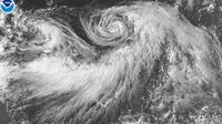
Hurricane Iona has rapidly emerged as a major force in the Central Pacific Ocean, marking the first significant tropical cyclone of the 2025 hurricane season. Spinning well south of the Hawaiian Islands, Iona has captured the attention of meteorologists and residents alike, although it poses no immediate threat to land.
On the evening of Sunday, July 27, 2025, Tropical Storm Iona was named, becoming the first storm of the Central Pacific hurricane season, which officially runs from June 1 through November 30. Just 12 hours later, by Monday morning, July 28, the storm had intensified into the season's first hurricane. By Monday night, it had grown into a major Category 3 hurricane, with sustained winds reaching 115 miles per hour.
Continuing its rapid intensification, by 5 a.m. Hawaiian time on Tuesday, July 29, Iona's wind speeds had surged by more than 57 miles per hour within 24 hours, topping out at 125 miles per hour. This rapid strengthening is notable in the Central Pacific, where major hurricanes typically form only once every four to five years. Meteorologist Ryan Maue highlighted this acceleration on social media, noting, "In the past few hours, Hurricane Iona, well south of Hawaii, has continued to rapidly intensify in the tropical Central Pacific. A clearing eye = Category 4 satellite intensity estimates." While forecasters anticipate Iona to briefly reach Category 4 status, steady weakening is expected to begin by Wednesday, July 30, as the hurricane moves into cooler waters and encounters drier air and stronger wind shear.
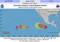
As of the latest advisories from the Central Pacific Hurricane Center and the National Hurricane Center, Iona was located approximately 765 to 790 miles south-southeast of Honolulu, Hawaii, moving westward at speeds around 13 to 20 kilometers per hour (8 to 13 mph). The storm's compact size is striking; hurricane-force winds extend only about 15 to 30 miles from the eye’s center, while tropical-storm-force winds reach out 60 to 90 miles. This small footprint limits its potential to affect a broad area.
Despite its strength, Iona's westward trajectory keeps it well away from the Hawaiian Islands, ensuring that the state will avoid direct impacts. The National Weather Service in Honolulu has confirmed that no coastal watches or warnings are in effect. While isolated thunderstorms may affect far southern offshore waters, the primary weather influence from Iona will be modest increases in swell and slight wind upticks along the southern shores of Hawaii.
Following closely behind Iona is Tropical Storm Keli, the second named storm of the season. Keli is much smaller and weaker, with sustained winds near 40 miles per hour as of Tuesday morning, July 29. Positioned about 960 miles southeast of Honolulu and moving west at approximately 12 mph, Keli is not expected to strengthen significantly and is forecast to dissipate by Wednesday, July 30. Like Iona, Keli poses no direct threat to the Hawaiian Islands.
The Central Pacific hurricane season is generally less active than its Atlantic counterpart. While the Atlantic averages 14 named storms per year, the Central Pacific typically sees up to five tropical cyclones, including tropical depressions, storms, and hurricanes. August is historically the most active month in the Central Pacific, accounting for around 40% of tropical cyclone activity according to historical data from 1971 through 2013. This year’s official forecast anticipates up to four tropical cyclones between June and November, with a 50% chance of near-normal activity, 30% chance of below-normal, and a 20% chance of above-normal activity.
The current phase of the El Niño Southern Oscillation (ENSO) is neutral, meaning neither El Niño nor La Niña conditions are present. This neutral status suggests that local weather factors, such as water temperature, wind shear, and dry air presence, will play a more significant role in determining the season's activity than broader ENSO influences.
While the Central Pacific basin awakens with these two storms, the Atlantic hurricane season remains unusually quiet, with only four named storms so far this year, three of which never made landfall. Meteorologist Luis Antonio Morales Ocaña attributes this lull to Saharan dust and cooler Atlantic waters but warns that conditions could change rapidly with the arrival of tropical waves from Africa, as the Caribbean Sea currently experiences warmer temperatures conducive to storm development.
Beyond the tropical cyclones, Hawaii is also preparing for a series of ocean swells. A large long-period south swell, generated several hundred miles east of New Zealand, is expected to arrive by Thursday, July 31, coinciding roughly with the passage of Iona and Keli. Derek Wroe, a meteorologist with the National Weather Service in Honolulu, cautions that "people might wrongly attribute the swell energy to be from these tropical systems, but they’re actually not." The swell is forecast to build south shore surf to near summertime average levels on Wednesday and peak at around 4 to 5 feet on Thursday, maintaining surf heights above the High Surf Advisory threshold through Friday. Another sizable south swell is expected early next week.
Trade winds are also predicted to strengthen, pushing east shore surf to seasonal averages by late Wednesday or Thursday and sustaining those levels into the weekend. Meanwhile, flat summer conditions on north-facing shores may be briefly interrupted by a northwest swell from Typhoon Krosa, currently active in the western Pacific.
Experts emphasize that Iona and Keli will remain far enough from Hawaii to avoid significantly influencing trade winds or exacerbating fire weather threats in the state. The Hawaii Emergency Management Agency hosted a statewide conference call on Monday, July 28, to coordinate monitoring efforts across all counties, with National Weather Service officials providing updates. Agency spokesperson Kiele Amundson confirmed, "All counties are monitoring." The public will be kept informed should any changes arise.
The emergence of Hurricane Iona and Tropical Storm Keli signals an active period in the Central Pacific, reminding residents and observers that even quieter basins can surprise with sudden bursts of activity. As meteorologist Andy Hazelton of the University of Miami CIMAS remarked, "#Iona is a small but impressive hurricane. Goes to show that hurricanes are mesoscale to synoptic systems, and can sometimes form even if the seasonal factors...make them less likely." This season's developments underscore the importance of vigilance and preparedness, even when storms remain distant.