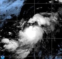
Hurricane Gil has emerged in the eastern Pacific Ocean, marking a notable development in a typically busy period for storms in the region. As of Friday, August 1, 2025, the Miami-based U.S. National Hurricane Center (NHC) confirmed that Tropical Storm Gil had strengthened into a Category 1 hurricane. Situated approximately 1,080 miles (1,740 kilometers) west-southwest of Mexico's Baja California Peninsula, Gil boasts maximum sustained winds of 75 mph (120 kph) and is moving west-northwest at 20 mph (31 kph).
Despite its intensification, Gil is not expected to threaten any land areas. There are currently no coastal watches or warnings in effect, allowing residents along the Pacific coast to breathe a sigh of relief. Forecasters anticipate the hurricane will continue its west-northwest trajectory, moving further into the Central Pacific Basin over the coming days.
Gil's strengthening comes amid a flurry of tropical activity across the Pacific Ocean. The FOX Forecast Center reports that, as of early August, two named storms and three additional disturbances are active in the basin. While none of these systems are forecast to impact land, their presence highlights a dynamic atmospheric pattern that is expected to shift toward the Atlantic basin in the following week, potentially influencing weather systems there.
Another named storm, Iona, which had previously reached hurricane status, has weakened significantly. As of August 1, Iona was downgraded from a tropical storm to a tropical depression, with maximum sustained winds dropping to 35-40 mph (55-65 kph). It is located far west of Hawaii, near the International Dateline, and poses no threat to land. The National Hurricane Center and other meteorologists continue to monitor several other areas in the eastern Pacific for potential tropical development. One such area southwest of southwestern Mexico holds a high chance of development within the next seven days, while a new disturbance south of Central America has a lower chance but remains under watch.
Hawaii, although not directly threatened by these storms, may experience increased wave action as a result of the churning seas. This has prompted Fire Weather Warnings for the state, emphasizing the indirect impacts even distant storms can have on coastal regions.
The current period of tropical activity comes as the Atlantic hurricane season is just beginning to ramp up. Meteorologists note that June and July historically account for only about 12% of all named storms since records began in 1851, with August and September typically seeing the peak of activity. While the early season has been relatively quiet, recent model data has sparked interest among forecasters.
Long-range computer models, such as the European and GFS (Global Forecast System) models, have shown hints of potential low-pressure systems developing off the U.S. Gulf Coast in early to mid-August. The European model's run from August 1 indicated the formation of a low-pressure area off the southwest coast of Florida around August 7, which could then move toward Louisiana by August 13. Additionally, it suggested another low-pressure system off the U.S. east coast. Meanwhile, the GFS model also hinted at lowered pressure near Louisiana around August 12, though it portrayed a broader and less organized system.
Ensemble models, which run multiple simulations to account for uncertainties, show some support for these potential systems but with varying degrees of confidence. The GFS ensemble members indicate several possible low-pressure areas scattered from South Texas to the Central Caribbean and near the Bahamas, though these signals are not particularly strong. The European ensemble models similarly show some support for tropical activity in the Caribbean and Gulf regions in the first half of August.
Meteorologists caution that these model runs represent possibilities rather than certainties, especially given the inherent challenges in long-range forecasting. Past seasons have seen promising model signals that failed to materialize into actual storms. Nonetheless, these indicators are taken seriously as the hurricane season progresses toward its climatological peak.
In recent years, the National Hurricane Center has refined its forecasting methods to better communicate risks. The hurricane forecast cone, which illustrates the probable path of a storm's center, is recalculated annually based on forecast errors and has been steadily shrinking, reflecting improved prediction accuracy. Furthermore, last year saw the addition of inland watches and warnings to the forecast cone to emphasize the impacts of tropical systems beyond coastal areas.
There has also been a shift away from focusing solely on the Saffir-Simpson hurricane scale categories toward impact-based forecasting. This approach aims to inform the public about the potential effects of storms—such as flooding, wind damage, and power outages—rather than just their wind speed categories. As one meteorologist noted, impacts can be severe far inland, where storm surge is not a factor but flooding and power outages can cause significant hardship.
Experts stress the importance of preparedness, especially as the season moves into August and beyond. While the early months have been relatively quiet in terms of named storms, the atmosphere is showing signs of waking up. Tropical waves off the west coast of Africa are being monitored, and clusters of thunderstorms in the Atlantic's main development region could eventually organize into tropical cyclones.
Local meteorologists in the southeastern United States are actively engaging communities to raise awareness and readiness. For example, in Savannah, Georgia, a severe weather expo is scheduled for August 2, featuring educational activities, giveaways, and participation from agencies like the American Red Cross and local emergency management. Such efforts aim to ensure residents are informed about hurricane risks and prepared for potential threats.
In summary, Hurricane Gil's formation in the eastern Pacific is a reminder that the tropical cyclone season is underway, with multiple systems active across the basin. While Gil and Iona currently pose no threat to land, the evolving atmospheric patterns and model forecasts suggest that tropical activity may increase in the coming weeks, particularly in the Atlantic basin. Residents in hurricane-prone areas should remain vigilant and prepared as the season progresses.