Hurricane Erin, the first named hurricane of the 2025 Atlantic season, has left a trail of disruption and anxiety along the eastern seaboard of the United States and Canada, even as it weakens and speeds away into the North Atlantic. On August 21, 2025, New Jersey declared a state of emergency, bracing for the storm’s impacts that included coastal flooding, dangerous rip currents, and gale-force gusts, according to the BBC and USA Today. The National Hurricane Center (NHC) continued to warn early on August 22 that Erin, despite drifting away from North America, still posed a threat to life and property.
At its peak, Erin reached Category 5 status on August 16, with maximum sustained winds near 90 mph (150 km/h) and hurricane-force winds extending outwards as far as 125 miles (205 km) from its center. The storm’s enormous size meant that hurricane and tropical-storm-force winds swept across vast stretches of coastline, bringing with them the risk of storm surges, flooding, and treacherous surf conditions from Florida all the way to Atlantic Canada.
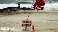
Though Erin never made landfall in the continental United States, its effects were felt up and down the coast. Beach and road closures became the norm, as authorities in states like New Jersey, North Carolina, and Virginia scrambled to keep residents and visitors safe. In New Jersey, Governor Phil Murphy cited high winds, large waves, and flooding as the main reasons for his emergency declaration. "Over the past couple of days, we have seen the effects of Hurricane Erin along the Jersey Shore in the form of dangerous rip tides. Today and tomorrow will be no exception," Murphy said, as reported by the BBC.
Elsewhere, the NHC warned that Massachusetts, Nova Scotia, and Newfoundland would also feel the brunt of strong gusts and pounding surf. Environment Canada flagged the Burin and southern Avalon Peninsulas as areas of particular concern, noting the risk of "large waves, pounding surf, and higher than normal water levels." Beachgoers were strongly advised to stay out of the water across most of the US east coast, with the NHC emphasizing that rip currents can swiftly drag even experienced swimmers out to sea.
As Erin churned northward, the storm’s outer bands battered the Outer Banks of North Carolina, flooding roads like Highway 12 and prompting the evacuation of communities such as Hatteras and Ocracoke. Residents feared the worst, as the storm threatened to sever these barrier islands from the mainland. Carol Dillon, a 96-year-old motel owner on Hatteras, shared her anxiety with CBS News, saying, "This is our livelihood. We could lose those two buildings that are in the water right now. I'm hoping we won't – I do a lot of praying."
By Friday morning, the maximum observed wind gust in the United States was 53 mph in Cape Hatteras, according to AccuWeather. Erin also produced a storm surge of around three feet along portions of North Carolina's Outer Banks and southeastern Virginia, with waves in the surf zone reaching heights of 10 to 20 feet. In New Jersey, coastal flooding forced the closure of U.S. 40 in both directions near Atlantic City. Delaware was not spared either, as water washed over the tops of dunes and caused beach erosion near the Indian River Inlet, the National Weather Service reported.
Florida, too, remained on high alert. The National Weather Service in Melbourne issued a stark warning: "Numerous, strong, life-threatening rip currents are expected, along with 3-4 foot surf and seas 4-6 feet high. Stay out of the ocean!" Conditions along the Florida coast were expected to return to normal only by the weekend, USA Today noted.
Even the skies were not immune to Erin’s reach. On August 18, a Spirit Airlines flight from Philadelphia to San Juan flew directly through the hurricane’s path. Despite the ominous conditions, the airline reported that the flight was completely safe, with only light turbulence experienced at 37,000 feet. Michael McCormick, coordinator of the Air Traffic Management Program at Embry-Riddle Aeronautical University, told USA Today, "At that altitude, the aircraft would be above the significant weather with the worst activity to the north of the flight path." At the time, Erin was a powerful Category 4 storm.
Erin’s impacts were not limited to the U.S. mainland. More than 150,000 residents in Puerto Rico lost power temporarily as high winds damaged electricity lines, according to local energy company Luma. Meanwhile, the Bahamas, Bermuda, and Atlantic Canada braced for rough ocean conditions, with swells generated by Erin expected to cause life-threatening surf and rip currents for several days. The NHC urged beachgoers to heed warnings from lifeguards and local authorities, as the dangers would persist even as the storm moved away.
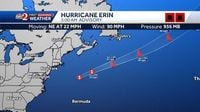
As of 5 a.m. on August 22, Erin’s center was located near latitude 38.6 North, longitude 65.3 West, moving northeast at 22 mph. The storm was expected to become post-tropical by nightfall, but would remain a powerful hurricane-force low-pressure system through the weekend. Hurricane-force winds still extended up to 125 miles from the center, and tropical-storm-force winds as far as 370 miles, ensuring that large swaths of coastline remained under threat from wind, waves, and flooding.
Despite Erin’s gradual weakening, the NHC and Environment Canada both warned that the storm’s impacts would linger. Wind gusts to tropical storm force were possible in extreme southeastern Massachusetts, while gale-force gusts could strike Nova Scotia and Newfoundland through August 23. Coastal flooding was expected at times of high tide along parts of the U.S. Mid-Atlantic and New England coasts, making some roads impassable and causing significant beach erosion and overwash.
The 2025 Atlantic hurricane season, which runs from June 1 to November 30, is forecasted to be particularly active. Meteorologists point to warmer sea temperatures—exacerbated by climate change—and favorable atmospheric conditions as key factors behind the above-average storm outlook. However, concerns are mounting over recent cuts to American research funding, which experts fear could hamper the nation’s ability to track and prepare for these often-deadly storms.
As Erin moves off into the open Atlantic, leaving behind battered coastlines and anxious communities, the storm serves as a sobering reminder of the power of nature and the importance of preparation. With the hurricane season far from over, residents along the Atlantic coast remain watchful, hoping for calmer days ahead but readying for whatever the next storm may bring.


