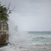
As Hurricane Erin churned across the Atlantic in mid-August 2025, its unpredictable path and fluctuating power left a trail of disruption and anxiety from the Caribbean to the U.S. Eastern Seaboard. What began as a rapidly intensifying storm—reaching a ferocious Category 5 status with 160 mph winds—soon transformed into a sprawling atmospheric menace, its vast outer bands lashing islands and threatening coastal communities hundreds of miles away.
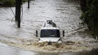
On Sunday, August 17, Erin had weakened to a Category 3 hurricane, but its danger was far from diminished. The storm’s outer bands pummeled Puerto Rico and the Virgin Islands with sheets of rain and tropical-storm-force winds, leaving flooded streets and battered homes in their wake. According to the Associated Press, nearly 147,000 customers in Puerto Rico found themselves without electricity that morning, as Luma Energy scrambled to restore power. More than 20 flights were canceled, stranding travelers and further underscoring the storm’s disruptive reach.
By late Sunday, Erin’s strength surged once again, regaining Category 4 status with maximum sustained winds of 130 mph. The National Hurricane Center (NHC) warned that "some additional strengthening is expected today," and even as some weakening was forecast for the coming night, the storm would "remain a large and dangerous major hurricane through the middle of this week." The NHC’s advisories painted a picture of a storm whose true threat lay not just in its core, but in its growing size—doubling or even tripling as it moved northwest, casting a wide net of perilous surf and rip currents up and down the U.S. East Coast.
Despite the storm’s center staying at least 200 miles from the North Carolina coast, officials in Dare County were taking no chances. They declared a state of emergency and issued a mandatory evacuation order for Hatteras Island starting Monday, August 18. The Outer Banks, a slender ribbon of barrier islands beloved by vacationers, faced the prospect of several days of heavy surf and high winds. According to the National Weather Service, parts of North Carolina Highway 12—the only road threading through Hatteras—could become impassable as ocean overwash and flooding set in. "Coastal flooding and ocean overwash are expected to begin as early as Tuesday ... and continue through Thursday," Dare County officials warned, adding that life-threatening conditions could persist for days.
Elsewhere, the Turks and Caicos Islands and the southeast Bahamas were placed under tropical storm warnings. The NHC forecasted additional rainfall of 2 to 4 inches, with locally higher amounts up to 6 inches, across these islands through Tuesday. In Puerto Rico, rainfall totals since Friday night reached 6.28 inches in Cayey, while St. John in the U.S. Virgin Islands recorded 7.32 inches, according to the National Weather Service’s San Juan office. The deluge brought a heightened risk of flash and urban flooding, landslides, and mudslides, especially in mountainous and urbanized areas. "Locally considerable flash and urban flooding, along with landslides or mudslides, are possible," the NHC cautioned, echoing the experiences of residents who saw rivers and streets swell to dangerous levels.
Despite the chaos, there were moments of resilience and even normalcy. In San Juan, fishermen cast their lines into storm-swollen rivers, while surfers caught the last big swells before Erin’s arrival. Yet, the specter of the hurricane loomed large, and memories of previous devastating storms—like Hurricane Helene, which claimed over 200 lives in the southeastern United States just a year prior—remained fresh. The Atlantic hurricane season, running from June to late November, was already forecast to be more intense than usual, with meteorologists warning of an increased likelihood of powerful storms.
As the storm’s core passed east and northeast of the Turks and Caicos and the southeastern Bahamas overnight into Monday, August 18, the threat shifted northward. Bermuda and the central Bahamas were advised to closely monitor Erin’s progress, as the storm was expected to turn north and then northeast, possibly bringing similar hazardous conditions. The NHC emphasized that while a direct U.S. landfall was not expected, the expanding storm would generate dangerous waves and rip currents along the entire East Coast, from Florida to New England and even up to the Canadian Maritimes. "Swells generated by Erin will spread to the Bahamas, Bermuda and the US and Canadian east coast in the coming days, creating life-threatening surf and rip currents," the agency warned.
The Coast Guard responded swiftly, reopening all ports in Puerto Rico and the U.S. Virgin Islands as winds and rains subsided on Sunday. But the recovery was only just beginning. Flooded roads, submerged homes, and widespread power outages posed ongoing challenges for residents and emergency crews alike. In the Outer Banks, the looming evacuation and the threat to critical infrastructure like Highway 12 were stark reminders of the region’s vulnerability to storms that never even make landfall.
Underlying Erin’s rapid intensification and unpredictable behavior was a growing body of scientific evidence linking such phenomena to climate change. According to multiple sources, including AFP and the Associated Press, human-driven global warming—primarily from the burning of fossil fuels—has raised ocean temperatures, providing hurricanes with more energy. The result? More frequent and severe storms that can intensify with astonishing speed. Erin, for instance, rocketed from a Category 1 to a Category 5 hurricane in just over 24 hours, a transformation that, as scientists note, is becoming more common in a warming world. "You’re dealing with a major hurricane. The intensity is fluctuating. It’s a dangerous hurricane in any event," said Richard Pasch of the National Hurricane Center.
Yet, even as the science becomes clearer, the resources to confront these storms are under strain. The National Oceanic and Atmospheric Administration, which oversees the NHC, has faced budget cuts and staffing reductions, raising concerns about the nation’s ability to forecast and respond to such hazards. For communities in the path of Erin and future storms, the need for accurate, timely information—and the resources to act on it—has never been more acute.
As Erin continues its journey across the Atlantic, its legacy is already taking shape: a stark reminder of nature’s power, the vulnerabilities of coastal communities, and the urgent challenges posed by a changing climate. For those living in its shadow, the days ahead promise a difficult test of resilience and preparedness.


