As Hurricane Erin barreled northward along the Atlantic this week, North Carolina’s Outer Banks found themselves once again at the center of an all-too-familiar drama. By Wednesday, August 20, 2025, the region’s iconic Highway 12—a 150-mile lifeline connecting the barrier islands—was already showing signs of flooding, with officials and weather forecasters sounding increasingly urgent alarms. The Outer Banks, celebrated for their windswept beauty, historic lighthouses, and bustling tourism, were bracing for a storm that, while not expected to make landfall, threatened to upend lives and reshape coastlines.
The National Weather Service (NWS) in Newport/Morehead City wasted no time in calling Erin a “large and dangerous hurricane,” warning that its impacts would not be fleeting. According to the NWS, “coastal flooding, storm surge, and overwash has already begun,” and the effects were expected to peak Wednesday night into Thursday, with some areas feeling the storm’s wrath through Friday. The National Hurricane Center (NHC) echoed these warnings, issuing a storm surge warning from Cape Lookout to Duck, North Carolina, and a tropical storm warning stretching from Beaufort Inlet, NC, to Chincoteague, VA, including the Pamlico and Albemarle sounds.
By 5 p.m. ET on Wednesday, Erin’s center was about 295 miles from Cape Hatteras, but its reach was undeniable. The storm’s tropical storm-force winds extended as far as 265 miles from its center, ensuring that even communities far from the eye felt its power. The NWS cautioned, “Numerous roads will likely be impassable under several feet of water and vehicles will likely be submerged.” Residents were urged to move cars to higher ground and prepare for a “long duration event.”
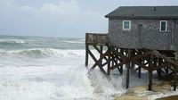
Highway 12, the backbone of the Outer Banks, was a particular focus for both officials and locals. The North Carolina Department of Transportation had spent days stacking sand at least 10 feet high along vulnerable stretches, hoping to stave off the worst of the storm surge. But as the department admitted, “given the winds, wave heights and storm surge forecast, it likely won’t be enough.” By Wednesday evening, sections of Highway 12 on Hatteras Island were completely submerged, forcing its closure. Photos and videos circulating online showed powerful waves slamming into homes and businesses, and the familiar sight of red “no swimming” flags fluttered ominously in the wind.
Evacuations were swift but tense. Mandatory orders were issued for Hatteras and Ocracoke islands, with the window to leave closing rapidly as the storm’s approach accelerated. More than 2,000 people managed to escape via ferries by Wednesday morning, many of them using Highway 12 to reach safer ground inland. Governor Josh Stein, who had declared a state of emergency earlier in the week, made his position clear: “The window is closing for tourists and residents to evacuate. And if you have not evacuated, make sure you batten down the hatches.” Stein emphasized the importance of Highway 12, noting, “There’s so many people who live there, there’s so much tourism dollars that goes on that road. It is an important asset to the state, and we need to do everything we can to protect and preserve it.”
For those who stayed behind, the warnings were stark. Chief Jack Scarborough of the Hatteras Island Rescue Squad cautioned, “If water starts to surround your home, move to the highest level and stay there until it starts to recede. Do not think it’s over after the first high tide—conditions could persist into Friday.” Emergency crews were on standby, but as Scarborough noted, deteriorating conditions could make it impossible for them to reach those in need.
While Erin’s center remained offshore, its effects were felt far and wide. The NHC warned beachgoers up and down the East Coast to heed local advisories and stay out of the water, highlighting the risk of “life-threatening surf and rip currents.” Swells and dangerous currents were expected from Florida to Massachusetts, as well as in Atlantic Canada, the Bahamas, and Bermuda. The National Ocean Service described rip currents as “powerful, narrow channels of fast-moving water” and advised that swimmers caught in one should move parallel to the coastline before angling back to shore. Several states, including New York, closed beaches to swimming as a precaution.
Even as Hurricane Erin was forecast to weaken by Friday, the NWS warned that hazardous beach conditions would persist for days, with “significant impacts” lingering due to powerful swell energy and elevated tides. Coastal flood alerts were issued for low-lying areas across the East Coast, including Delaware and New Jersey, and tropical storm conditions were expected to reach as far as Bermuda, the mid-Atlantic, and southern New England coasts through early Friday.
For the Outer Banks, Erin was just the latest in a series of punishing storms. The region, which juts out precariously into the Atlantic, has suffered significant damage from rising sea levels and increasingly severe storm swells in recent years. Last year’s Hurricane Helene, for example, left at least 108 dead and caused nearly $60 billion in damages across North Carolina, according to research cited by the Associated Press. Scientists note that while the overall frequency of hurricanes has not increased, their severity has, largely due to warmer ocean temperatures driven by climate change. This warming amplifies storm intensity, leading to higher casualties and escalating property losses.
Local residents and vacationers faced tough choices as Erin approached. On the beach in Duck, North Carolina, Rick Wash, a tourist from Smithfield, Virginia, tried to strike a balance between caution and calm. “So I can monitor the Coast Guard channels,” he explained, clutching his hand-held radio as he secured deck furniture and watched the churning surf. His attitude reflected a blend of stoicism and pragmatism that’s become second nature for those who frequent the Outer Banks.
As Thursday dawned, Erin, classified as a Category 2 hurricane with winds up to 105 mph, began to slowly pull away from the coast. Yet, the aftermath was far from over. The NWS reported that “impacts will peak today,” with the worst conditions expected during high tide cycles. Flooding, storm surge, and high surf continued to threaten communities, and the closure of Highway 12 left some areas temporarily isolated. Authorities reminded everyone that just because the eye of the storm had moved on, the dangers—especially from water—remained very real.
The Outer Banks, shaped by centuries of storms and shifting sands, once again faced the test of resilience and adaptation. For now, the focus remains on recovery, safety, and the hope that, this time, the scars left behind will heal a little faster.