Hurricane Erick has rapidly intensified off the Pacific coast of Mexico, setting a course that could bring devastating impacts to the southern coastal regions, according to the U.S. National Hurricane Center (NHC). Forming on Wednesday, June 18, 2025, Erick has already reached Category 2 status with sustained winds nearing 100 mph, and forecasters expect it to strengthen further into a major hurricane before making landfall early Thursday morning.
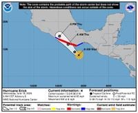
As the fifth-named storm of the Eastern Pacific hurricane season, Erick is poised to be the first hurricane to strike Mexico this year. The NHC reported that the hurricane was located approximately 160 miles south-southeast of Puerto Ángel, Mexico, moving northwest at around 7 to 8 mph. Its projected path brings it dangerously close to the resort city of Acapulco, which suffered catastrophic damage from Hurricane Otis in October 2023.
Otis, a Category 5 hurricane, devastated Acapulco with wind speeds that surged by 115 mph in a single day, leaving at least 52 people dead and 32 missing. The memory of that disaster is fresh, and local authorities are taking no chances this time. Guerrero state Governor Evelyn Salgado announced the closure of all schools on Wednesday and the preparation of 582 shelters to accommodate potential evacuees. A hurricane warning is in effect from Acapulco to Puerto Ángel, signaling that hurricane conditions are expected and that residents should expedite preparations to protect life and property.
The NHC emphasizes that Erick's rapid intensification could bring winds strong enough to cause "devastating damage". Major hurricanes, classified as Category 3 or higher, have sustained winds between 111 and 129 mph, capable of snapping or uprooting many trees, blocking roads, and causing widespread power and water outages lasting days or even weeks. Hurricane-force winds currently extend 15 miles from Erick's center, with tropical storm-force winds reaching 105 miles.
But wind is only part of the threat. Erick is forecast to unleash torrential rainfall, with totals reaching up to 20 inches across Oaxaca and Guerrero. These downpours pose a serious risk of life-threatening flash floods and mudslides, especially in mountainous and steep terrain. Other states including Chiapas, Michoacan, Colima, and Jalisco are expected to receive between 2 to 8 inches of rain, while Mexico City could see lighter but still significant precipitation.
Coastal communities must also brace for a dangerous storm surge and large, destructive waves that could cause coastal flooding. The NHC warns that "water hazards—storm surge and inland flooding—have historically been the leading causes of loss of life during hurricanes." The storm will also generate life-threatening rip currents along the coast, further complicating safety efforts.
Forecasters expect Erick to approach the southern coast of Mexico late Wednesday night and move inland or near the coast on Thursday, June 19. After landfall, the storm is predicted to weaken back to tropical storm strength by Thursday night as it moves northwest across Mexico. However, heavy rain may continue through Friday, prolonging the risk of flooding and mudslides.
Residents and officials are urged to heed warnings and act swiftly. The National Oceanic and Atmospheric Administration (NOAA) advises early preparation, including assembling disaster supplies, creating evacuation plans, and securing insurance coverage—especially flood insurance, which requires a 30-day waiting period. Strengthening homes by trimming trees and installing storm shutters is also recommended.
AccuWeather lead hurricane expert Alex DaSilva highlighted the storm's potential impact, stating, "We expect Erick to drift northwestward and close in on the southwestern coast of Mexico. Erick will rapidly strengthen for a time as it approaches the coast. Erick may track very close to Acapulco with the full impacts you would expect from a hurricane, ranging from powerful wind gusts and power outages to torrential rain and flash flooding, as well as storm surge flooding."
The Eastern Pacific hurricane season, which began on May 15, 2025, has already been active, with Tropical Storm Alvin, Hurricane Barbara, Tropical Storm Cosme, and Tropical Storm Dalila preceding Erick. Yet, Erick stands out as the most dangerous to date, particularly given its expected rapid intensification and the vulnerable areas it threatens.
With the storm's projected path and intensity, the humanitarian and infrastructural stakes are high. The lessons learned from Hurricane Otis’s devastation have prompted more robust emergency responses, but the challenges remain formidable. As the storm barrels toward the coast, the focus turns to preparedness and resilience in the face of nature’s fury.
In the coming hours, southern Mexico will face a severe test as Hurricane Erick approaches, bringing with it the potential for life-threatening flooding, destructive winds, and widespread disruption. Authorities continue to monitor the situation closely, urging residents to stay informed and take all necessary precautions.