As the first day of fall unfolded across the Ozarks and beyond, communities in Missouri and California found themselves grappling with a deluge of rain, persistent thunderstorms, and the looming threat of flooding. From the rolling hills of Dent County to the rugged slopes of the San Bernardino Mountains, the week of September 21, 2025, has been marked by turbulent weather, anxious residents, and determined recovery efforts.
In Missouri, the National Weather Service (NWS) Springfield issued a flood advisory for Dent County on September 21, 2025, after steady rainfall from strong thunderstorms drenched the region. According to the NWS, between two and three inches of rain had already fallen by Sunday evening, with more expected to continue throughout the night. The advisory, which remained active until 10:45 PM CDT, warned that minor flooding could occur in low-lying and poorly drained areas—a familiar refrain for locals who have weathered similar storms in the past.
"Minor flooding was expected in low-lying places and areas where water does not drain well," the NWS cautioned in its advisory. Residents and visitors were urged to exercise caution, particularly in vulnerable spots where water tends to accumulate. The NWS also highlighted that several key tourist destinations within Dent County could be impacted, potentially disrupting travel plans and local businesses alike. With tourism playing a vital role in the area’s economy, even minor weather events can ripple through daily life.
Local emergency services and shelters were put on alert, prepared to assist stranded tourists and residents if conditions worsened. Meanwhile, authorities recommended that travelers reconsider their plans, and businesses braced for the possibility of delayed or canceled visits. Still, the spirit of the Ozarks remained resilient. As the NWS reminded everyone, "Safety remains the top priority for both locals and visitors, and authorities are taking the necessary steps to mitigate risks associated with the storm."
Just a few hours’ drive southwest, the broader Ozarks region was experiencing its own weather rollercoaster. According to KY3, after a night of rain and thunderstorms focused south of Springfield, temperatures on Sunday, September 21, rebounded into the lower to middle 80s. But the reprieve was short-lived. Scattered thunderstorms persisted into the evening, especially south of Highway 44 and Springfield, before tapering off to scattered showers and a few storms after midnight. Areas along and south of Highway 60 were expected to see more scattered showers and thunderstorms from midday into Monday afternoon, while those north of Highway 60 and Springfield could look forward to a mainly dry day under partly sunny skies.
Monday evening was forecast to bring a brief respite, with mostly dry conditions and partly to mostly cloudy skies. But the calm wouldn’t last. Widespread rain and thunderstorms were on tap for Tuesday, September 23, with rain totals projected to range from a quarter to three-quarters of an inch in the northern Ozarks and a hefty 1 to 4 inches elsewhere through 1 PM. The soaking was expected to continue through Tuesday afternoon, Wednesday, and into Thursday, with an additional 1 to 3 inches possible as a second upper-level low pressure system moved through. While the rain was a welcome sight for those hoping to ease dry conditions, the forecast came with a warning: localized flooding could threaten some communities on Tuesday.
"While all that rain is certainly good to see to put a dent in our dry conditions, we’ll continue to monitor the potential for at least a localized flooding threat on Tuesday," KY3 reported, underscoring the delicate balance between drought relief and flood risk. For those yearning for a return to sunshine, the outlook brightened by Thursday afternoon, when dry weather was expected to settle in for the upcoming weekend.
Temperatures, meanwhile, were set to follow the whims of the weather. Monday’s first day of fall was expected to start with morning lows in the middle 60s before climbing to near 80 or the lower 80s by afternoon—a warm start to the season. Tuesday’s persistent clouds and rain would keep highs in the lower 70s, with below-normal temperatures lingering through midweek. By Friday, however, forecasters predicted a rebound to the middle or upper 70s and even near 80 for the weekend, while morning lows would dip into the brisk mid-to-upper 50s.
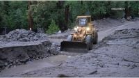
While Missouri braced for more rain, California’s San Bernardino Mountains were already deep in recovery mode after a devastating storm. On Thursday, September 18, 2025, heavy rain unleashed massive flooding and mudflows in communities like Forest Falls, Oak Glen, and Potato Canyon. By Saturday, September 21, recovery efforts were in full swing. According to the San Bernardino Sun, the storm triggered mud and debris flows that severely damaged homes in Forest Falls and stranded motorists on Highway 38 and Oak Glen. The damage assessment, completed by Saturday, found three single-family residences destroyed, one with major damage, two with minor damage, and five partially damaged (9% or less).
Highway 38 remained closed from just east of Angelus Oaks at Mill Creek Road to Lake Williams Drive in Big Bear due to ongoing mudflows, with Caltrans urging motorists to find alternate routes. The saturated mountainsides, weakened by previous fire damage, gave way under the weight of the stormwater. Fortunately, no injuries or rescues were reported, and evacuation warnings were lifted by Saturday, allowing residents to return home. Cleanup efforts, however, were expected to continue for days, if not weeks.
San Bernardino County Fire Department spokesman Christopher Prater explained, "The damage assessment for homes in Forest Falls was completed Saturday." He detailed the extent of the destruction, while San Bernardino County Sheriff’s Department spokeswoman Mara Rodriguez noted that "the saturated mountainsides gave way because water from the storm combined with damage left behind by previous fires." Rodriguez added that cleanup efforts remained underway and directed residents to local public works for updates.
For residents in both Missouri and California, the events of the past week have been a stark reminder of the unpredictable power of nature. In Dent County, the focus remained on staying safe and informed as rain continued to fall, while in the San Bernardino Mountains, the community rallied to rebuild and recover from the mud and debris left behind. Across the Ozarks, the forecast pointed to more rain, cooler temperatures, and—eventually—a return to the golden, crisp days that mark the heart of autumn.
As the clouds slowly part and the waters recede, communities from the Ozarks to Southern California are left to pick up the pieces, draw lessons from the storms, and look ahead to brighter, drier days.