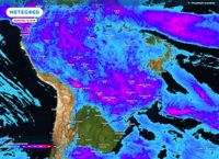
On Wednesday, April 16, 2025, heavy rains are set to intensify across various regions of Brazil, particularly affecting the Midwest and Southeast. The National Institute of Meteorology (INMET) has issued alerts indicating that instability in weather patterns will escalate during the early morning hours, impacting the center-east and northeast of Mato Grosso do Sul, as well as parts of Mato Grosso, Goiás, and the Federal District.
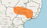
Regions in the south of Goiás and the northeast of Mato Grosso do Sul are currently under an orange alert, signaling a high level of danger due to anticipated rainfall amounts that could reach up to 100 mm per day, accompanied by wind gusts of up to 100 km/h. This alarming forecast raises concerns about potential flooding, landslides, and river overflows in the affected areas.
In Campo Grande and Ponta Porã, the maximum temperatures are expected to hover around 28ºC, amidst a backdrop of rain showers. Meanwhile, in other parts of Goiás, the Federal District, and Mato Grosso, the sun may peek through clouds, with temperatures dropping slightly to a maximum of 26ºC in the DF, while Cuiabá could see highs of 32ºC and Goiânia around 30ºC.
Earlier this week, on Monday, April 14, INMET had already issued a storm alert for 17 states, which included Minas Gerais, Rio de Janeiro, Espírito Santo, Goiás, Mato Grosso, and São Paulo. These alerts were prompted by a cold front that caused intense rains in several municipalities, leading to red alerts for regions expecting rainfall between 20 and 30 mm/h, along with strong winds. The north-central region of Brazil was also under an orange alert, with forecasts predicting up to 50 mm/h.
The Intertropical Convergence Zone (ZCIT) has been identified as a contributing factor to the increased likelihood of storms, bringing moisture from the Amazon to the Atlantic Ocean. Meteorologist Andrea Ramos emphasized that Belo Horizonte, the capital of Minas Gerais, is particularly vulnerable to severe weather, with expectations of heavy rain, gusty winds, thunderstorms, and even hail.
As the situation unfolds, authorities are urging residents to take precautions. INMET recommends avoiding unnecessary travel during adverse weather conditions and staying alert to changes in nearby slopes. They advise residents to disconnect electrical appliances and the main power supply to prevent accidents, and to seek shelter away from trees and tall structures during strong winds.
With the forecast indicating continued rain over the upcoming weeks, it is crucial for residents in affected areas to remain informed and heed the guidance of local authorities. The potential for significant disruptions to daily life, including power outages and traffic difficulties due to flooding, necessitates community cooperation to mitigate impacts.
In addition to the imminent storms, forecasts for the month of April suggest that rainfall levels in the North, South, and Southeast regions are expected to be above or near average. Conversely, the central-east and much of the Northeast are projected to experience below-average precipitation. April is traditionally a transitional month in Brazil, marking the shift from the rainy summer season to the drier autumn and winter months.
As Brazil braces for the impending weather challenges, the focus remains on ensuring public safety and preparedness. Local authorities are on high alert and ready to respond to emergencies, reinforcing the message that community vigilance is vital in navigating these turbulent weather patterns.
Residents are encouraged to stay updated on weather forecasts and to follow the recommendations provided by the Civil Defense and Fire Department, with emergency contact numbers readily available for those needing assistance. The cooperation of the public is essential in minimizing risks and ensuring safety during this period of heightened weather instability.
In summary, as Brazil faces the threat of heavy rainfall and severe weather conditions, the collaboration between authorities and the community will be pivotal in managing the potential impacts of these storms. The situation remains dynamic, and continued monitoring and preparedness will be essential in the days ahead.