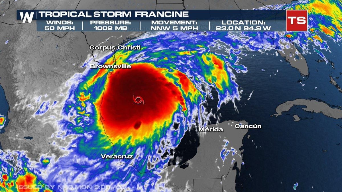
Storm alerts are blaring along the Gulf Coast as Tropical Storm Francine intensifies, projected to make landfall as a hurricane by Wednesday evening. The National Hurricane Center (NHC) has issued hurricane warnings for various coastal regions, particularly focusing on Louisiana and Texas, which could face life-threatening conditions as the storm draws nearer.
Having formed over the warm waters of the Gulf of Mexico, Francine is expected to rapidly gain strength, potentially achieving hurricane status as maximum sustained winds are already reported at 60 miles per hour. Forecasters are hinting at the possibility of the storm reaching Category 2 status upon landfall, which is usually characterized by damaging winds of 96 to 110 mph.
Lafayette, Louisiana, is among several coastal communities gearing up for the impending storm, with memories of past hurricanes still fresh. Residents recall the devastation of Hurricane Laura back in 2020, and local authorities are urging families to prepare for potential evacuations. Anthony Bartie, president of the Calcasieu Parish Police Jury, has activated emergency response plans, emphasizing the urgency of readiness, particularly for those residing in low-lying areas.
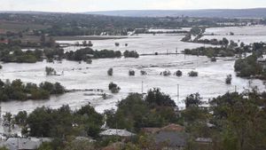
"This storm is expected to bring threats of heavy rain, gusty winds, and possibly tornadoes," said Sharon Weston Broome, the Mayor-President of Baton Rouge. The latest projections indicate heavy rainfall amounts could range from 5 to 12 inches across parts of Louisiana, intensifying concerns about flash flooding.
Authorities are taking preemptive measures. Shell has paused operations on its oil rigs near the storm's path, evacuations are underway for non-essential staff, and sandbagging stations have been set up to help prevent flooding. These precautions are necessary as flash flooding poses significant risks due to the region's already saturated ground conditions.
The Gulf Coast is facing the double-edged sword of increased preparedness and looming dangers. Storm surges—a significant rise in sea levels associated with hurricanes—could reach as high as 10 feet, particularly affecting low-lying areas and putting local levees to the test. Although current forecasts suggest the levee systems may hold, it’s unclear how much water those structures may have to manage.
"The NHC has flagged risks for both storm surge and damaging winds, which pose serious threats to coastal communities, especially as the storm draws closer," emphasized meteorologists following the development of Francine. The storm is currently located about 180 miles south-southeast of the mouth of the Rio Grande, moving steadily toward the U.S. coastline.
On Tuesday, conditions are expected to worsen as the storm approaches the Texas and Louisiana coastlines. Areas like Galveston, Houston, and Beaumont are forecasted to receive several inches of rain, leading to potential flooding issues, alongside the risk of tornadoes through southern Louisiana and Mississippi as the storm progresses inland.
With the storm's arrival just before the seasonal peak of hurricane activity, government and local officials are reflecting on recent years of unpredictable weather patterns fueled by climate change. Record warm ocean temperatures have already been linked to increased storm intensity, spurring fears of what other hurricanes might develop as this season continues.
A level of uncertainty remains, though. Variability among computer models presents differing trajectories and potential impacts for the storm, with current sentiments leaning toward danger for central and southwestern Louisiana. Forecast accuracy will remain key as residents await more detailed updates.
Meanwhile, the broader juxtaposition of weather systems provides insight not only to the unpredictability of hurricanes but also to the larger climatic shifts at play. The Gulf Coast is part of a larger narrative of increasingly severe weather, hinting at intense discussions on climate resilience and community preparation moving forward.