On Saturday, May 10, 2025, Mobile County experienced a significant weather event as the National Weather Service issued a flash flood warning at 2:51 a.m., in effect until 6 a.m. Doppler radar indicated thunderstorms producing heavy rainfall, with between 2 and 4 inches already fallen across the area. Additional rainfall amounts of 1 to 3 inches were also anticipated, raising concerns about flash flooding.
Areas affected by the warning included Midtown Mobile, Downtown Mobile, Prichard, Tillmans Corner, Theodore, Chickasaw, Grand Bay, Bayou La Batre, and several major highways such as I10 and I65. The weather service cautioned residents, stating, "Flash flooding of small creeks and streams, urban areas, highways, streets, and underpasses as well as other poor drainage and low-lying areas is ongoing or expected to begin shortly."
Residents were urged to take immediate action in response to the flash flood warning. The National Weather Service emphasized the importance of safety, reminding people to "turn around, don't drown" when encountering flooded roads. Flash floods can develop quickly, often taking just minutes to occur, and can be especially dangerous at night when visibility is reduced.
In addition to the flash flood warning, the weather service provided a breakdown of weather alerts, defining terms such as flood warnings and advisories. A flood warning indicates that flooding is imminent or occurring, while a flood advisory is issued when conditions may lead to flooding but are not severe enough to warrant a warning.
As the rain continued to fall, the weather service outlined essential flood safety guidelines for residents. They advised moving to higher ground if in a flood-prone area, adhering to evacuation orders, and avoiding basements or submerged areas to prevent electrical hazards. They also warned against walking through floodwaters, as just 6 inches of swiftly moving water can knock a person off their feet, and 12 inches can carry away most vehicles.
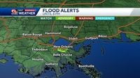
Meanwhile, in Southeast Louisiana, heavy rain left multiple flood alerts across the region, particularly impacting the New Orleans Metro area. A flash flood warning was in effect for parts of Saint Charles and a small portion of Saint John the Baptist Parish until 7:15 p.m. on Friday, May 9, 2025. A flood advisory was also issued for the Metro New Orleans area until 8:00 p.m. that same day.
Reports indicated that some areas of New Orleans received nearly 3 inches of rain, while Metairie recorded the highest rainfall total at 4.4 inches. City Park saw just over 3.5 inches, and Downtown New Orleans also experienced significant rainfall. Armstrong International Airport recorded over 2 inches, and Lakefront had nearly 2.5 inches.
As the weather continued to evolve, forecasters noted that pockets near Slidell reported close to 2 inches of rain. The National Weather Service indicated that while there was still a threat of isolated storms bringing locally heavy rain on Saturday, the chances were lower than in previous days.
Looking ahead to the Mother’s Day weekend, the forecast predicted a high of 78 degrees on Sunday, May 11, 2025, with a 30% chance of rain. Morning temperatures were expected to start in the 60s, gradually warming throughout the day. By noon, temperatures would reach around 76 degrees, and by 2 p.m., they could peak at 78 degrees.
Weather experts highlighted the importance of staying informed and prepared during such weather events. They recommended following local authorities' advice and being cautious, particularly when navigating roads during heavy rain. Visibility can be severely affected, and the first half-hour of rain is often the slickest due to a mix of rain and oil on the roads.
As the weekend approached, the National Weather Service continued to monitor conditions closely, issuing updates as necessary. They reminded residents that flooding can pose a significant threat, especially in low-lying areas and during severe weather events. The message was clear: preparation and awareness are key to staying safe during these unpredictable weather patterns.
In conclusion, as Mobile County and the New Orleans Metro area grapple with the impacts of heavy rain and flash flooding, residents are encouraged to heed warnings and take necessary precautions. With the weather service providing guidance and updates, staying informed is crucial to navigating these challenging conditions safely.