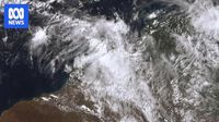
Ex-Tropical Cyclone Errol made landfall off Western Australia’s Kimberley coast on Friday afternoon, April 18, 2025, as a tropical low, bringing with it warnings of severe weather and heavy rainfall. Although the cyclone weakened below tropical cyclone intensity shortly after 2:30 PM, it still posed significant risks to residents in the area.
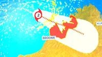
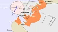
The Bureau of Meteorology reported that Errol crossed the coast just south of Kuri Bay, with wind speeds reaching up to 95 km/h. As the system moved inland, it was expected to track in an east-south-easterly direction, impacting central Kimberley on Saturday, April 19, 2025. Residents living between Mitchell Plateau and Cockatoo Island were advised to prepare for heavy rainfall that could lead to flash flooding.
Severe weather warnings were issued for locations between Kuri Bay and Mount Barnett, with the Department of Fire and Emergency Services (DFES) urging locals to be cautious of floodwaters. A spokesman stated, "Never walk, drive, ride, swim or play in floodwaters as they are dangerous. If driving, obey road closure signs and do not drive into water of unknown depth and current." DFES is actively monitoring the situation, with some roads likely to be closed.
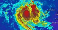
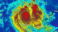
Earlier in the day, Cyclone Errol had approached as a Category 2 storm but ran out of steam just before making landfall. The slow-moving system brought sustained winds of 45 km/h near the center and wind gusts of up to 75 km/h when it made landfall approximately 85 kilometers south-southeast of Kuri Bay. The Bureau of Meteorology warned that locally intense rainfall about the north Kimberley coast could lead to dangerous and life-threatening flash flooding.
Forecasts indicated that six-hourly rainfall totals could reach between 100-140 mm, with isolated falls in thunderstorms exceeding 150 mm. Heavy rain was anticipated to continue over the next few hours, especially in Wyndham, Kalumburu, and Troughton Island.
As the cyclone approached, residents were urged to stay indoors and secure loose items around their properties. DFES Kimberley Superintendent Leon Gardiner emphasized that preparations were critical, stating, "DFES is maintaining a cyclone advice 'prepare now' for people between Kuri Bay to the north of Broome, including those Kimberley coastal islands." He encouraged residents to take the time to prepare for severe weather over the coming days.
Peter Tucker, who operates Kuri Bay Sport Fishing, expressed confidence in his staff's preparedness for the tropical low. "It shouldn't be too dramatic; the boys are well-versed in preparation for such weather, so I'm not too concerned," he said. He noted that while heavy rain and wind were expected, Kuri Bay was well-constructed to handle such conditions, with the primary concern being the potential for shade sails to come down.
Mount Gibson Iron, located at Koolan Island, also indicated it was closely monitoring the weather system and had activated its cyclone-readiness protocols as required.
As Errol made its approach, it marked the 11th tropical cyclone in the Australian region for the season, making this the most active tropical cyclone season in six years. This comes as communities across New South Wales and Queensland continue to deal with the aftermath of ex-Tropical Cyclone Alfred, which caused widespread destruction and left thousands without power.
In summary, while Ex-Tropical Cyclone Errol has weakened, the potential for heavy rainfall and flash flooding remains a serious concern for residents in the Kimberley region. Authorities continue to monitor the situation closely, urging locals to stay informed and prepared as the storm moves inland.