The weather forecast for the province of Cuneo from Saturday, April 12, 2025, to Monday, April 14, 2025, indicates a gray sky with a series of disturbances expected to bring rain to the region. However, the rain between Sunday and Tuesday is predicted to struggle to reach the Po Valley. According to local reports, between Wednesday and Thursday, a third disturbance may arrive, accompanied by sirocco winds, which could enhance precipitation across all sectors.
As for the immediate forecast, today, Saturday, April 12, the sky is expected to be overcast with weak prefrontal precipitation affecting the Cozie mountains. The real rain is anticipated to start overnight, extending into the afternoon of Sunday, April 13. Winds will be from the east, with temperatures remaining stable.
On Sunday, the forecast predicts a continuation of overcast skies with more intense rain during the night, followed by possible pauses and uneven distribution of rainfall. The Po Valley is expected to receive less rain due to a marine component that will tend to dry the air. Winds will continue from the east, maintaining a general breeze regime, while temperatures will stay steady.
Moving to Monday, April 14, a new front is expected to bring rain starting from the night and potentially continuing throughout the day. However, the forecast remains uncertain, with a reliability of only 60%. Winds will be variable, with no significant values to report, except in the middle and upper Tanaro valley and the passes towards Liguria, where winds could strengthen between the afternoon and evening. Overall, temperatures are expected to remain stable.
In Rome and Lazio, the weather forecast for Sunday, April 13, 2025, predicts a sharp drop in temperatures by as much as 10 degrees, alongside rain and strong winds. This significant change is attributed to the arrival of an intense disturbance affecting much of Italy, particularly the northern regions. Despite this phase of bad weather lasting a few days, temperatures are expected to rise again, approaching 20 degrees.
In specific areas like Rieti and Viterbo, maximum temperatures are not expected to exceed 12 degrees. In Rome, minimum temperatures will reach 10 degrees, while maximums will not surpass 15 degrees. Rain is forecasted to begin at 11 a.m. and continue into the evening, though no particularly intense precipitation is anticipated. Similar conditions are expected in Latina, with temperatures ranging from 9 to 15 degrees, while Frosinone will see minimums of 11 degrees and maximums of 15. Rieti and Viterbo will experience cold temperatures, with minimums not dropping below 8 degrees and maximums not exceeding 12.
Monday, April 14, will also bring bad weather, with rain and cloudy skies. However, changes are expected starting Tuesday, April 15, when temperatures will rise and rains should cease, allowing for a return to warmer conditions above 20 degrees, although new waves of bad weather cannot be ruled out.
In Liguria, the stable and sunny weather that characterized the previous days is giving way to the return of Atlantic currents, bringing clouds and rain. The first signs of this change are already affecting the region on Sunday, April 13, and are expected to intensify on Monday, April 14, when significant weather events are likely in Liguria di Levante. This bad weather is projected to continue in the coming days due to a cyclonic circulation that is expected to remain blocked to the west of Italy.
On Monday, April 14, Liguria will experience widespread rain, including showers and thunderstorms. Specifically, the Riviera di Ponente, the Alps, and the Apennines will see disturbed weather with extensive rain, while the central and eastern rivieras will have very cloudy skies with light rain, intensifying in the afternoon with thunderstorms. Winds will be weak from the north, rotating to the northeast, and the sea conditions will be very rough.
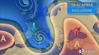
On Tuesday, April 15, the cyclonic circulation responsible for rain will ease, providing a temporary dry break in the afternoon. However, rain is expected to return in the evening. The weather on Wednesday, April 16, will remain unstable with light rain across all sectors, intensifying in the afternoon. The forecast for Thursday, April 17, indicates that the cyclonic circulation will move away, allowing for clearer skies by the evening.
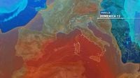
As for the broader weather situation across Italy, the high pressure that has provided several days of mild weather is weakening. An incoming disturbance from Spain is set to bring rain to many regions in the Center-North, extending to parts of Southern Italy between Monday and Tuesday. This marks the beginning of a disturbed phase that will characterize much of the Easter week, with another disturbance expected at the end of Tuesday, bringing more bad weather through Wednesday and Thursday. A final disturbance could arrive on Easter Sunday, April 20, although this forecast remains uncertain.
For today, April 13, the weather will start with glimpses of sun over Puglia, Basilicata, Calabria, and Sicily, but clouds are expected to increase later in the day. The rest of the country will see cloudy to overcast skies with scattered precipitation in the North and most central regions, with intensifying phenomena expected in Liguria, Emilia Romagna, Tuscany, Umbria, and Marche in the afternoon and evening. Maximum temperatures will decrease in the North but increase in the Center-South, particularly in the South and Islands where peaks between 25 and 30 degrees are possible. Winds will strengthen from the Scirocco, particularly over the seas.
In summary, the weather across Italy is shifting dramatically this weekend, with widespread rain and cooler temperatures expected in many regions. As we head into the week, the forecast suggests continued instability, particularly as we approach Easter, making it a time for residents to prepare for unsettled weather.