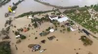
Severe flash flooding resulting from torrential rains has wreaked havoc in southern Spain, particularly near Málaga, where 365 homes have been evacuated in the suburb of Campanillas. The persistent storms have forced authorities to halt classes in eight local schools and shut down multiple roads due to dangerous conditions. As many as nineteen rivers are currently on high alert, reflecting the relentless rise in water levels.
Storm Laurence, which impacted the region overnight, has left a staggering amount of rainfall, nearly 100mm, accompanied by gusty winds reaching 90 km/h. The Guadalhorce Valley, a particularly hard-hit area, saw the Campanillas River burst its banks, inundating entire streets with floodwaters. The overflow has extended to other rivers, including the Turón and the Guadalhorce, which have left parts of nearby locations, such as Cártama and Almogía, submerged, complicating recovery efforts.
In response to the crisis, the Casasola dam, having surpassed its designed capacity of 22 million cubic meters and now holding 25 million, is being closely monitored. Authorities have initiated controlled water releases into the Campanillas River to mitigate the risk of structural damage, even though it heightens the flood risk downstream. Emergency services are actively engaged in cleanup operations while displaced residents are finding temporary shelter and assessing the damages.
The impacts of climate change are being cited by scientists and government officials as contributing factors for the extreme weather patterns that Spain has been experiencing, which now includes a cycle of prolonged drought followed by sudden, catastrophic downpours. With reservoirs currently at critical levels and infrastructure already strained from the severe flooding, experts raise concerns that such weather events may become more frequent in the future.
As emergency protocols are put in place, local officials are advising residents to remain cautious due to the fluctuating river levels. They are explicitly warning that further evacuations could be necessary if conditions continue to deteriorate. The situation remains tense as recovery and monitoring efforts are ongoing.
Adding to the woes, meteorological forecasts indicate that Storm Martinho is on its way, expected to bring more rain to Málaga and surrounding areas starting Thursday afternoon, March 20, continuing through the weekend. Before Martinho arrives, there is a brief dry spell anticipated on March 19, providing some respite to overwhelmed residents.
As per the director of the Aemet state meteorological centre in Málaga, Jesús Riesco, Storm Martinho will be less severe than its predecessor, Storm Laurence, but still requires attention. “The intensity will have to be seen day by day, but it will not be as high as Laurence,” Riesco noted. Rains throughout the province could be expected, with a slight risk signified by yellow warnings activated in four provinces—Almería, Granada, Huelva, and Seville—but currently, not in Málaga.
Residents are being urged to remain prepared for Saturday, March 22, and Sunday, March 23, when showers may be frequent. Furthermore, some rainfall may persist into Monday, March 24, and Tuesday, March 25, although to a lesser extent, adding to the cumulative effects of the persistent weather systems affecting the region.
As Storm Laurence and subsequent storms like Martinho continue to influence daily life in Andalucía, the urgent need for comprehensive strategies to address water management and infrastructure must be addressed as flooding becomes a recurring concern. With climate change intensifying these weather patterns, adaptive measures will be crucial to mitigate future disasters and protect vulnerable communities.