As summer 2025 officially kicked off, sweltering heat and dangerous conditions swept across much of the United States, prompting heat advisories and warnings for millions of residents. From the Northeast to the South and Midwest, the heat wave brought record-breaking temperatures, oppressive humidity, and severe weather threats, demanding vigilance and caution from communities nationwide.
Massachusetts experienced its hottest day of the year on Thursday, June 19, 2025, with Boston finally hitting 90 degrees Fahrenheit for the first time this year. The National Weather Service issued a heat advisory for most of southern New England, excluding the South Coast, from 11 a.m. to 8 p.m. Temperatures ranged between 90 and 95 degrees, but with dew points nearing 70 degrees, the "feels-like" temperatures soared close to 100 degrees in the afternoon. This was a notable milestone, as Boston had just missed the 90-degree mark the previous Thursday, topping out at 89 degrees. Last year, the city didn’t reach 90 degrees until June 18, and only had 12 days above that threshold throughout 2024.
Alongside the heat, central and western Massachusetts faced a "slight" risk of severe thunderstorms, according to the Storms Prediction Center. An approaching cold front was expected to trigger storms between 2 and 10 p.m., moving from west to east across the state. These storms could bring heavy downpours, frequent lightning, small hail, damaging winds, and even a small chance of isolated tornadoes. The highest risk area remained west of Route 495, where the cold front’s timing could maximize severe weather potential. Residents were advised to stay alert as conditions evolved throughout the day.
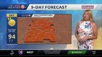
Meanwhile, in Kansas City and surrounding areas, the heat wave was just beginning to intensify on Friday, June 20, 2025. The National Weather Service declared it a First Alert Weather Impact Day due to a heat advisory starting at 1 p.m. Temperatures were expected to climb to 94 degrees in Kansas City, with nearby Lawrence, Atchison, Hiawatha, and Maryville potentially reaching 96 degrees. Marshall and Warrensburg were forecasted to hit 92 degrees. The heat index, which factors in humidity, could reach up to 103 degrees, placing the area in the uncomfortable, if not dangerous, heat category. The advisory was expected to continue through the weekend, with Saturday also marked as an Impact Day. Winds were predicted to gust up to 40 miles per hour, adding to the challenging weather conditions. Sunday and Monday were forecasted to remain hot, with highs in the low 90s and heat indices exceeding 100 degrees. Only by midweek was there a slight chance of rain, with a 30% probability starting late Tuesday night.
Further south, the ArkLaTex region faced a heat advisory on Friday, June 20, 2025, issued by the National Weather Service-Shreveport. Heat indices were expected to climb between 105 and 109 degrees, with actual temperatures approaching triple digits in some areas. Residents were urged to take extra precautions if planning outdoor activities during the advisory period from 11 a.m. to 7 p.m.
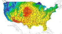
In the Mid-Atlantic and Midwest, the heat wave was even more expansive and intense. According to the National Weather Service, over 42 million people were under extreme heat watches, and more than 37 million under heat advisories across the central United States on the morning of June 20. Additionally, over 20 million faced extreme heat warnings. The difference between these alerts is critical: a heat advisory signals dangerous heat conditions, while an extreme heat warning means extremely dangerous heat is expected or already ongoing.
Temperatures on June 20 ranged from triple digits in parts of Kansas, Nebraska, and North Dakota to the low to mid-90s in the Southeast and high 80s in the Midwest and Mid-Atlantic. Overnight, some upper Midwest and Northern and Central Plains areas risked record high minimum temperatures, offering little relief from the heat. AccuWeather forecasters described the event as a "significant and extremely dangerous heat wave" expected to last well into the week of June 23, with above-90s temperatures spreading across the eastern half of the country.
Major cities like Washington, D.C., and New York were bracing for stretches of five to seven consecutive days with temperatures reaching 90 degrees or higher. AccuWeather Senior Meteorologist Chad Merrill remarked, "The magnitude and longevity of this heat wave will be a shock to the system." The humidity accompanying the heat was expected to make conditions feel even hotter, with overnight lows offering scant relief in many areas.
The heat wave’s timing followed a round of severe thunderstorms on June 19 that swept through the Mid-Atlantic, particularly impacting the Philadelphia metro area. Winds reached 70 miles per hour, downing trees and power lines, and leaving over 150,000 homes and businesses without power across Philadelphia and neighboring counties. By early June 20, utility company PECO had restored power to about 165,000 customers, but the outages underscored the vulnerability of infrastructure during extreme weather events.
Philadelphia was forecasted to have a brief respite from the heat on June 20, with highs in the 80s, but temperatures were expected to climb again over the weekend. Saturday’s high was predicted at 91 degrees, Sunday at 95, and Monday at 99, with triple-digit temperatures possible later in the week. Heat indices were expected to top 100 degrees for multiple days, prompting public health warnings.
Heat remains the deadliest weather hazard in the United States, having caused more fatalities in 2024 than floods, tornadoes, wind, or hurricanes. Health officials emphasized precautions such as using sunscreen, wearing loose and light-colored clothing, avoiding leaving children or pets in cars, staying hydrated, seeking shade or air conditioning, and being especially cautious for vulnerable populations like children, the elderly, and pregnant individuals.
Down in Southeast Louisiana, New Orleans was also grappling with intense heat and scattered thunderstorms. On June 19, high temperatures reached about 93 degrees, a few degrees above the average high of 90. The low was 78 degrees, also above average. A Heat Advisory was in effect until 7 p.m., with another set to begin the next day from 11 a.m. to 7 p.m. on June 20. Feel-like temperatures, factoring in humidity, were expected to range from 100 to as high as 112 degrees on Friday, with heat indices remaining above 100 degrees through the weekend.
Scattered showers and thunderstorms were expected to continue, with spotty storms possible late in the afternoon on the South Shore, Metro, and Northshore areas. Rain chances hovered around 40% through Sunday, increasing to 60% on Monday, and then settling back to 40% through Thursday. Thunderstorms on June 19 were expected to end by 9 p.m., with another round beginning as early as 2 p.m. on June 20, becoming more numerous near the South Shore and Metro before winding down by 8 p.m. A subsequent round was anticipated early on June 21.
Despite the rain chances, an upper-level high-pressure system was maintaining hot and humid conditions, limiting the spread of widespread storms. Forecasters noted that the tropics appeared quiet, with no expected developments over the next seven days, offering some relief from the storm threat but not from the heat.
Across the nation, the start of summer 2025 has been marked by this sprawling heat wave, challenging public health systems, infrastructure, and personal safety. With temperatures soaring and humidity intensifying the discomfort, staying informed and taking precautions remain vital as communities endure these dangerous conditions.