As Cyclone Tam approaches Aotearoa New Zealand from the north, the country braces for an intense weather event characterized by heavy rain and strong winds. The storm, which was recently downgraded from a tropical cyclone, is expected to bring significant impacts to the North Island, particularly in Northland and Auckland, starting from Wednesday, April 16, 2025, through to Friday, April 18, 2025.
According to MetService, the forecast indicates that easterly and northeasterly winds will reach unusually high speeds, prompting Orange Warnings for Strong Winds in both Northland and Auckland. Gusts near the Auckland Harbour Bridge could approach 100 km/h on Wednesday and may exceed that threshold on Thursday. The storm’s winds pose a risk of damage to trees, structures, and power lines, leading to hazardous travel conditions across the region.
"The most likely areas for coastal impacts stretch from North Cape down to Coromandel, with the highest risk around high tide. People are encouraged to follow the advice of local authorities and avoid the coast if possible," said MetService meteorologist Mmathapelo Makgabutlane.
As the storm approaches, Northland has already experienced a wet start to the day, with a Heavy Rain Warning in effect. Orange Warnings for Heavy Rain have also been issued for Coromandel and Western Bay of Plenty, while northern Tairāwhiti/Gisborne and northwest Tasman are expected to see similar warnings from Thursday evening. A Watch remains in place for Auckland.
Heavy rainfall is expected to be significant, with forecasts predicting up to 180mm in some areas. Thunderstorms are also possible on Thursday in Northland and northern Auckland, which could intensify the effects of the ongoing heavy rain and strong winds.
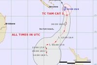
Cyclone Tam was officially reclassified earlier on Wednesday as it moved south over cooler waters. Despite this downgrade, it remains a powerful and potentially damaging system with expected rainfall and strong winds affecting a wide area of the country.
"This is going to be pretty substantial," commented a MetService representative, highlighting the potential for significant impacts as the storm progresses.
In addition to the strong winds, dangerous sea and coastal conditions are anticipated for the upper North Island. Large waves, with swells of 5 to 6 metres, are forecast, which could lead to coastal inundation and erosion. Residents along the coast are advised to exercise caution and heed local warnings.
The NZ Transport Agency (NZTA) has also issued warnings for motorists, advising them to prepare for hazardous driving conditions. "This orange warning may extend further into the Waikato region and the Kaimai Range. With school holidays and Easter around the corner, roads are busier than usual," said Andrew Brosnan, the Waikato Journey Manager for NZTA.
As the storm continues to approach, emergency services and local councils have been mobilized to prepare for the potential impacts. Civil Defence has met with local emergency services, councils, contractors, and partner agencies to ensure readiness for response operations if necessary.
"This is not just a storm; it’s a serious weather event that could disrupt many lives," said a Civil Defence spokesperson, urging residents to stay informed and prepared.
In Whangārei, high winds have already caused disruptions, including a blocked lane on State Highway 1 due to a fallen tree. Fire and Emergency services responded promptly to clear the road. Reports have also surfaced of a 12-metre concrete yacht sinking at Totara North, although it is not considered a navigational hazard.
As the weather system progresses, it is expected to impact not only the North Island but also extend southward into the upper South Island. Rainfall is anticipated to spread across various regions, with warnings in place for many areas.
Residents are advised to secure outdoor furniture, clear gutters, and prepare emergency supplies in case of power outages. Auckland Transport has warned that public transport services, particularly ferries, may be affected due to increased risks on the roads.
"Make sure you check the forecast when planning any weekend travel or activities and check it again for any changes before you go out. If you're heading to another region, check the weather there too," advised Auckland Emergency Management general manager Adam Maggs.
As the storm continues to develop, MetService emphasizes the importance of staying updated through their Severe Weather page, which provides the latest information on expected weather conditions and safety advice.
In summary, Cyclone Tam presents a significant weather threat to New Zealand, particularly in the North Island, where residents are urged to exercise caution and prepare for severe weather conditions in the coming days.