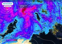
A cyclone is hitting Italy, causing heavy rainfall and windstorms on Thursday, April 17, 2025, especially in the Center-North. The cyclone is moving from Corsica towards the Ligurian Sea and Tuscany, becoming more tropical-like with extreme rain.
Over 150 mm of rain are expected in Piedmont on Thursday, April 17, 2025, with heavy rainfall also in Liguria, Valle d’Aosta, Lombardy, and Tuscany. Rainfall amounts expected on Thursday, April 17, 2025, include 160 mm in Biella, 150 mm in Aosta, 100 mm in Turin, 90 mm in Cuneo, and 50 mm in Genoa and Massa Carrara. There is a risk of flooding and landslides, particularly in the North-West on Thursday, April 17, 2025.
Winds are expected to reach over 100 km/h, especially in Puglia and Calabria on Thursday, April 17, 2025. On Friday, April 18, 2025, the weather will improve, but there will still be scattered showers. On Saturday, April 19, 2025, there will be good weather over most of Italy, but another disturbance is approaching from the Atlantic.
There will be new rains for Easter, Sunday, April 20, 2025, in the same areas affected by the severe weather: North-West and Sardinia. On Easter Monday, April 21, 2025, picnics are at risk of showers, especially in the Center-North. Italy is the most affected European country by the climate crisis, behind only Pakistan and Belize, according to the ‘Climate Risk Index 2025’.
Air instability, driven by a deep cyclone in Northern Europe, will increase the likelihood of showers and thunderstorms. The regions at higher risk are the Alps and Prealps, then the plains of Piedmont and Lombardy; isolated precipitations are also expected in Emilia Romagna. The phenomena are likely to be of short duration, although hailstorms cannot be ruled out.
Some thunderstorms are expected in the evening on the Tyrrhenian regions and on Abruzzo, Molise and north of Puglia. More sunny spells are expected in the North East, on a good part of the South (excluding Puglia) and on the two major islands. Temperatures are expected to increase with maximum peaks towards 20-22°C during the afternoon.
While the North of Italy is dealing with intense weather, attention is shifting towards the Easter weekend. A new disturbance is arriving between Saturday, April 19, 2025, and Easter Monday, April 21, 2025, potentially disrupting plans in some regions.
On Saturday, April 19, 2025, the weather will worsen with local phenomena starting from the North-West, particularly in Liguria, Piedmont, and Valle d’Aosta, with cloudy skies and scattered rains. On Sunday, April 20, 2025, the unstable front will advance towards Italy, bringing rain, thunderstorms, and sustained winds, but in an uneven manner.
The models indicate a marked deterioration in the North and part of the Center on Sunday, April 20, 2025, with locally intense phenomena in Liguria, Lombardy, upper Tuscany, and Emilia. Precipitation will gradually extend towards the Triveneto and the inland areas of the Center on Sunday, April 20, 2025. The South and Sicily will remain more protected on Sunday, April 20, 2025, thanks to a temporary rise in the African anticyclone.
On Monday, April 21, 2025, the context will remain gray in the North, with compact cloud cover and closed skies over many plain areas. In some areas of the Po Valley, the return of even heavy showers is not excluded, especially during the central hours of the day and in the afternoon.
In Central Italy, the situation will be rather fragmented, with threatening clouds and some scattered showers along the central Apennines and in the inland areas. In Southern Italy, the weather conditions will be generally more clement, with cloudy skies but without significant precipitation.
The Easter and Easter Monday weekend will be marked by variability in Emilia-Romagna. Episodes of intense instability will alternate with temporary phases of respite. A brief respite is expected from the end of Friday, April 18, 2025, until the first part of Sunday, April 20, 2025, due to the entry of a high-pressure wedge.
New disturbances may appear starting from Easter afternoon, Sunday, April 20, 2025. Until the evening of Thursday, April 17, 2025, intense episodes of showers and abundant rainfall may affect the hilly and mountainous areas of Emilia and part of Romagna. On Friday, April 18, 2025, the return of high pressure will bring a temporary stabilization.
Saturday, April 19, 2025, may be the driest and sunniest day of the entire week. On Saturday, April 19, 2025, temperatures will be around 20°C in the inland areas, and 22-24°C in the coastal areas. After a clear morning, on Sunday, April 20, 2025, an Atlantic front will start to advance, causing an increase in cloud cover and approaching showers.
On Sunday, April 20, 2025, phenomena could affect the Apennine sectors, Romagna, and the eastern areas of Emilia, with the possibility of thunderstorms in some exposed areas. For Easter Monday, April 21, 2025, some models suggest a phase of weak stabilization, especially in Northern Italy. In other areas, especially along the Apennines and in the eastern areas, the persistence of showers and localized phenomena is not excluded.
For Easter Monday, April 21, 2025, temperatures could remain around 20–22°C in the more exposed areas, while the minimum temperatures should be around 10–12°C. The advice for not panicking when organizing an outing? Monitor the evolution of weather conditions in the coming days and always remember that variability is typical of spring. Even in times of climate change and super-smart apps, not leaving home without an umbrella and a raincoat can be the right strategy to defend against the whims of the weather.