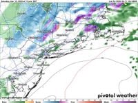
Connecticut residents woke up on Saturday morning, April 12, 2025, to a slushy coating of snow as a slow-moving storm system clashed with an unseasonably cold air mass. Rain and snow showers lingered throughout much of the day, accompanied by cold temperatures and gusty winds. The day began with temperatures in the 30s across the state, and high temperatures struggled to reach the upper 30s and lower 40s, which is around 15 to 20 degrees below normal for this time of year.
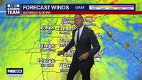
The gusty wind from the northeast, blowing at 15 to 35 mph, contributed to a significant wind chill, making it feel like the 20s throughout the day. This storm system qualified as a nor'easter, a weather phenomenon not uncommon in Connecticut but which tends to decrease in frequency as spring progresses. For those with outdoor plans, it was advisable to either reschedule or dress as if it were February.
As Saturday evening approached, clouds were expected to obscure the full "pink" moon, a nickname given to the full moon in April. Fortunately for those hoping for better weather, Sunday, April 13, 2025, promised to be an improvement over Saturday, although it would still be far from perfect. Temperatures were projected to be around 10 degrees warmer, and while wind gusts would ease slightly to 10 to 25 mph from the east, another chance of rain loomed as the pesky storm was reluctant to leave.
Fans attending the UConn women's basketball championship parade on Sunday were urged to dress warmly and carry an umbrella, as temperatures would be in the 40s, accompanied by cloudy skies and intermittent rain showers. However, major improvements were on the horizon for Monday, April 14, 2025, as the storm finally exited Connecticut, allowing sunshine to spread across the state. Temperatures were expected to jump into the 60s, marking a pleasant return to warmer weather after a cool and showery weekend.
For those in the shoreline areas, including Stamford, Bridgeport, New Haven, and New London, Saturday's forecast indicated cloudy conditions with intermittent rain showers and gusty winds from the northeast at 15 to 35 mph. Highs were expected to remain in the lower 40s. Inland areas, including Danbury, Waterbury, Greater Hartford, and Windham, faced morning snow showers mixing with rain, leading to intermittent rain showers for the rest of the day, with highs around 40.
In the Litchfield Hills, encompassing Torrington, Litchfield, and Winchester, morning snow (with minor accumulation on grassy surfaces) was forecast, followed by rain showers throughout the day, with highs expected between 36 and 41 degrees.
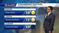
In contrast, Southeast Louisiana experienced a different weather pattern. A cold front pushed south and cleared the area early on Friday, April 11, 2025. Northerly winds brought slightly cooler air, but high pressure was building in behind the front, promising clear skies and dry conditions for the weekend. River flood warnings were in effect for Pearl River and Bogalusa, where the Pearl River was at minor flood stage, running at 16.01 feet.
On Friday night, temperatures in Southeast Louisiana dropped to near 49 degrees on the North Shore and 57 degrees on the South Shore, with northeast winds at 5 to 10 mph. The forecast for Saturday, April 12, 2025, indicated plenty of sunshine with high temperatures reaching near 75 degrees. The pleasant conditions were expected to continue into Sunday, April 13, 2025, with highs near 79 degrees.
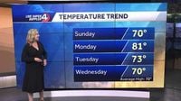
As the weekend progressed, the clear skies and mild temperatures were a welcome change after the storms that had developed the previous afternoon, bringing hail and heavy downpours. The recent rain had significantly helped alleviate drought conditions and combat wildfires in the region. By Sunday afternoon, temperatures were anticipated to rebound nicely, reaching near 70 degrees, with lower 80s expected on Monday, April 14, 2025, and Tuesday, April 15, 2025.
Western North Carolina experienced some of the cooler effects of the recent weather patterns, with afternoon highs primarily in the 50s and low to mid-60s on Saturday, April 12, 2025. The region faced frost and freeze conditions to kick off Sunday morning, April 13, 2025. However, by the afternoon, temperatures were projected to rise significantly, making for a beautiful day outdoors.
Overall, the weather across different regions varied significantly, with Connecticut facing a lingering nor'easter, Southeast Louisiana enjoying clear skies and mild temperatures, and Western North Carolina experiencing a chilly start but a warm afternoon. Residents across these areas were encouraged to take advantage of the sunshine and enjoy the spring activities planned for the weekend.
As the week unfolds, Connecticut residents can look forward to a return to warmer temperatures, while those in Southeast Louisiana and Western North Carolina will experience a gradual warming trend, with highs expected to remain near normal to slightly above average.