COLORADO RECIEVES COLD FRONT WITH HEAVY SNOW AND STRONG WINDS
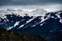
After weeks of unusually warm spring weather, a sharp cold front swept across Colorado on March 18, 2025, bringing a significant drop in temperatures along with rain and snow across much of the state. The National Weather Service has issued warnings, indicating that the high country is expected to receive between 10 to 15 inches of snow starting from Tuesday evening and continuing until Wednesday morning.
With the rapidly dropping temperatures, residents are cautioned about the potential for a flash freeze, posing hazardous travel conditions especially on mountain roads, including Interstate 70. Observers are advised to exercise extreme caution as conditions worsen.
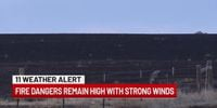
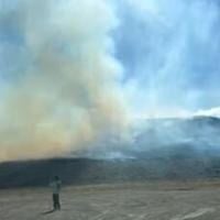
Alongside the expected snowfall, red flag warnings were also issued for the Denver metro area and eastern Colorado due to extremely strong winds, with gusts reaching around 60 mph. This dangerous mix of conditions has prompted Colorado Springs firefighters to alert residents to the high fire danger associated with strong winds observed on Monday, March 17, which carried over into March 18.
Maggie Ideker, a forecaster with the National Weather Service, indicated that although snow is projected for the surrounding mountain ranges such as the Rabbit Ears Range and Medicine Bow Mountains — with 6 to 10 inches expected there — conditions in the Denver metro area remain less favorable for snow accumulation. Ideker reported, “Temperatures will be just a little bit too warm for any snow,” forecasting only a trace of to half an inch of snow for the city.
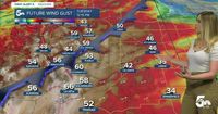
As temperatures plummeted, the storm started manifesting more intense weather phenomena. By March 18, red flag warnings were in effect for much of southeastern Colorado. Residents remained on alert as another round of high winds were forecasted to develop, with sustained gusts of 60-75 mph expected in manifold counties throughout the plains, potentially intensifying the fire risk.
What is perhaps most alarming is how this weather pattern is affecting life in Colorado. Local counties experienced a range in forecasts: Colorado Springs anticipated a high temperature of only 59 degrees Fahrenheit that day, with a significant uptick in wind speed from the west reaching 20-30 mph, gusting to over 50 mph later in the day. Pueblo forecasted slightly better conditions with high temperatures clocking in at 66 degrees, yet still under the threat of gusting winds. Canon City was set for sunny conditions but warned of potential spotty wintry mixes on the horizon.
Less central regions such as Woodland Park and the Tri-Lakes area are also preparing for significant weather; the forecasted highs hover between 49 and 53 degrees, with expected chances of snow transitioning into the evening. With storm systems approaching, weather experts predict conditions will change dynamically, leaving areas west of Interstate 25 could see snow showers.
Forecasters expect, however, that this storm could be followed by yet more systems hitting the area, bringing additional chances for snowfall into the upcoming weekend. Another weather update indicated that while conditions will ease by March 19, another system is projected to arrive late on March 21, bringing renewed snowfall to the mountains and parts of Colorado's broader regions.
Amid these forecasts, Ideker highlighted the fluctuating weather patterns this season have kept meteorologists on their toes. The only silver lining appears to be that, following this weather event, temperatures are set to rebound sharply. Current forecasts suggest the Denver metro area could enjoy highs in the 70s by March 24, and parts of southern Colorado may also experience highs in the 60s.
In conclusion, the state finds itself grappling with swiftly changing weather as winter weather looms, punctuated by warnings of high winds and fire danger interlaced with snow expectations. The call for caution is echoed across local and federal alerts, emphasizing the significant nature of this ongoing climatic event. Coloradans will have to remain vigilant as they prepare for the possibility of extreme weather conditions over the coming days.