The intense heat in Paraná is coming to an end with the arrival of cold fronts and polar air masses that promise to lower temperatures throughout April. According to meteorological forecasts, significant climate changes are expected as early as the beginning of the month, with the first cold front set to hit the state on Monday, March 31, 2025. This front will initially impact the southwest and west regions before spreading throughout Paraná.
As reported by Simepar, heavy rains are anticipated on Tuesday, April 1, and Wednesday, April 2, particularly in the central and coastal areas. These rains are part of a broader pattern, as three polar air masses are expected to influence the climate during the first half of April, with the third being the most intense.
On Sunday, March 30, 2025, the weather in Paraná was still hot, with highs exceeding 30°C in the interior and localized showers. However, starting Wednesday, April 2, temperatures are projected to become milder, marking a transition to a more typical autumn climate.
In Pato Branco, for example, temperatures are expected to start dropping, consolidating the shift to autumn-like conditions. By the end of April, a fourth, even more intense cold air mass may bring temperatures close to 10°C in some cities in Paraná. According to Simepar, specific forecasts indicate minimum temperatures of 8°C in Palmas, 12°C in Francisco Beltrão, and 10°C in Clevelândia.
In addition to Paraná, meteorological portals are also predicting the arrival of the first cold front of the year for the Rondonópolis region in early April. As highlighted by Clima Tempo, this front is expected to bring the first cold peak of the year to several regions of Brazil, including the South, Midwest, and Southeast, with a significant drop in both minimum and maximum temperatures.
While the models do not predict extreme cold, this will be the first mass of cold air to leave temperatures below the seasonal average, finally ushering in autumn conditions for the region. The first cold front is also expected to impact the southern parts of Mato Grosso, where Rondonópolis is located.
April is set to mark the effective start of autumn in Brazil, characterized by the arrival of the first polar air masses and a gradual change in rainfall patterns, as per Climatempo's forecasts. Meteorologists anticipate that the month will serve as a transition period, with shorter spans of mild temperatures in the Central-South region and a progressive reduction in precipitation across various areas.
Two polar air masses are expected to be prominent in April: one at the end of the first half of the month and another at the end of the month. The first temperature drop is forecasted between April 5 and April 8, bringing mild cooling to certain areas. This change will be felt in parts of the South and Southeast, as well as along the border of Mato Grosso do Sul with Paraguay.
Before the end of the first half of the month, a more pronounced cooling is anticipated, with the possibility of frost in the higher elevations of the South. In addition to the South region, the cold air mass should cause a moderate to strong drop in temperatures across parts of São Paulo and Minas Gerais, as well as in Rio de Janeiro, Espírito Santo, and western and southern Mato Grosso.
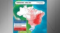
By the end of April, forecasts indicate the arrival of a stronger polar air mass, which will expand its coverage area. This cooling is expected to be particularly pronounced in the South, but a significant drop in temperatures is also anticipated in many areas of the Southeast and Midwest. Despite these incursions of cold air, April is still expected to feature warm days, with temperatures above average in most of the country. Only Rio Grande do Sul and Santa Catarina are expected to end the month with slightly below-average temperatures.
In terms of rainfall, April typically marks a reduction in precipitation across much of the national territory, a trend expected to continue this year. However, exceptions are anticipated in parts of the South, where rainfall is expected to accumulate above average, and in the extreme north of the country, influenced by the active Intertropical Convergence Zone (ZCIT).
Climatempo forecasts that the highest volumes of precipitation will occur in the first half of the month, particularly in the South and North of Brazil. States such as Amazonas, Pará, and Amapá, as well as the northern coast of the Northeast between Maranhão and Rio Grande do Norte, are expected to experience episodes of intense rain. In the eastern coast of the Northeast, especially in Salvador, rainfall is also expected to intensify, along with the coastal areas of the Southeast.
The combination of cold fronts passing through and elevated temperatures in the South Atlantic is likely to lead to heavy rain events in areas such as the coasts of São Paulo and Rio de Janeiro. The South is expected to experience several heavy rain events throughout the month, although the volumes are projected to be significantly lower than those recorded in 2024, when Rio Grande do Sul faced extreme precipitation episodes.
In the second half of April, a more pronounced decrease in rainfall is expected in the Southeast and Midwest, a characteristic typical of autumn that tends to intensify in May. While the first half of the month may see above-average rainfall in some regions, the latter half is anticipated to shift towards drier conditions.
As the country transitions into autumn, meteorologists advise residents to stay updated on weather forecasts and prepare for the expected climatic variations. The upcoming changes in temperature and precipitation patterns will be significant, marking a shift from the intense heat of summer to the cooler, more variable conditions of autumn.