The South African Weather Service (SAWS) has issued several warnings as a cold front is set to hit the Western and Northern Cape regions this weekend, bringing with it strong to gale-force winds and heavy rainfall. Residents are urged to prepare for potentially hazardous conditions starting Friday night, May 9, 2025, and continuing through the weekend.
According to SAWS, a Yellow Level 4 warning for damaging winds will be in effect between Table Bay and Plettenberg Bay until Saturday, May 10. This warning indicates a moderate risk of impact that requires caution, particularly for small vessels and informal settlements, which may face difficulties due to the expected rough seas and high winds.
Wayne Venter, a Senior Forecaster at the Cape Town Weather Office, explained that while this incoming cold front is not particularly intense, it will still result in cold and rainy conditions, as well as strong winds ranging from 30 to 50 km/h across most of the Western Cape and southern Northern Cape. "Residents should expect cloudy and cold conditions on Saturday, with rain and showers across Cape Town, the West Coast District, western Overberg, and the Cape Winelands," Venter noted. Rainfall amounts could reach between 10-20 mm, with higher elevations possibly receiving 25-40 mm.
In addition to the Yellow Level 4 warning, a Yellow Level 2 warning has been issued for the Hantam and Karoo Hoogland municipalities in the Northern Cape, where localized problems for high-sided vehicles are anticipated. This warning will be in effect starting mid-morning on Saturday until the evening.
As the cold front moves through, residents of the Karoo Hoogland in the Northern Cape and Witzenberg in the Western Cape can expect very cold, wet, and windy conditions. Strong gale-force winds are also predicted over the Chris Hani and Joe Gqabi district municipalities in the Eastern Cape, with very rough seas expected along the coast between Plettenberg Bay and Peddie on both Saturday and Sunday.
The SAWS has also warned of extremely high fire danger conditions over the interior of the Namakwa District, Kareeberg, and Kai!Garib Local Municipality in the Northern Cape, as well as the Central Karoo and Kannaland Municipality in the Western Cape. Meanwhile, the Eastern Cape is predicted to experience hot weather in some areas, contrasting with the cold conditions expected in the western provinces.
The City of Cape Town has alerted residents to the potential for falling trees, flying debris, and roof damage as the cold front approaches. Spokesperson Sonica Lategan emphasized the importance of securing outdoor objects that could be carried away by the wind and advised motorists to be vigilant for obstructions on roadways.
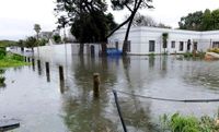
In a media briefing, Mnikeli Ndabambi, an executive at SAWS, highlighted the frequency of cold fronts in the region, particularly during the winter months. He noted that these weather systems can lead to severe disruptions, including heavy rains, flooding, and gale-force winds, which have previously affected informal settlements and caused significant damage to infrastructure.
Last winter, many communities in the Western Cape experienced hazardous weather conditions, with reports of roofs blown off and residents wading through floodwaters. Ndabambi stated, "Tens of thousands of people and property were affected, with severe cases of flooding reported in townships surrounding Cape Town and damage noted in areas such as Oudtshoorn, Elim, Cederberg, Knysna, and Mossel Bay." Power outages also impacted residents in various districts, including the Overberg, Garden Route, Central Karoo, and Cape Winelands.
As the weekend approaches, the public is advised to stay informed and take necessary precautions. The SAWS encourages residents to follow their updates on social media and through their website for real-time alerts and weather warnings.
In addition to the weather warnings, the forecast for other regions in South Africa on Friday, May 9, 2025, includes fine and cool conditions in Gauteng, with temperatures ranging from 11°C to 24°C in Johannesburg. Mpumalanga is expected to see warm weather in the Lowveld, while Limpopo will remain fine and warm, with hot conditions in some areas.
North West will also experience fine and cool conditions, while the Free State can expect cool and windy weather. In contrast, the Eastern Cape is predicted to start off cloudy with fog in the south, becoming fine and warm to hot as the day progresses. KwaZulu-Natal residents can look forward to clearing skies after a cloudy morning.
Overall, the weather this weekend in the Western and Northern Cape will be marked by cold temperatures, strong winds, and heavy rainfall, prompting urgent preparations for residents in affected areas. The SAWS is closely monitoring the situation and will provide updates as the weather system develops.