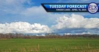
As the Finger Lakes region braces for a significant shift in weather, a cold front is set to sweep through the area on Tuesday, April 15, 2025. This system will bring with it increased winds, scattered showers, and the possibility of snow as temperatures drop throughout the day.
Weather forecasts indicate that the day will start with clear skies, but by late morning, puffy clouds will begin to form, leading to numerous showers in the afternoon. Some of these showers may even produce thunder and small hail as colder air moves in aloft, while surface temperatures are expected to reach the 50s. According to local meteorologists, most areas will experience rain during the midday and afternoon hours, although a few isolated spots might miss out altogether.
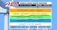
Wind conditions are also expected to intensify, with speeds peaking in the afternoon at around or slightly over 20 mph. Gusts could reach 40 to 45 mph, and some areas, particularly over the Bristol Hills and west of I-390, may see gusts approaching 50 mph. As the day progresses, temperatures will begin to fall, dipping into the 40s during the latter half of the afternoon and into the 30s shortly after sunset.
By Tuesday evening, rain showers are forecasted to transition into snow, particularly affecting regions along and north of I-90, as well as the Bristol Hills and higher elevations east of Cayuga Lake. Some of these areas could accumulate a couple of inches of snow overnight into Wednesday morning, with snow showers lingering into the afternoon of April 16, 2025. The strong winds will continue from the northwest, maintaining similar speeds as those experienced on Tuesday.
Temperatures on Wednesday are expected to hover in the mid to upper 30s, although some locations in the Southern Tier may reach the 40-degree mark. Following the cold front's passage, a brief warm-up is anticipated on Thursday, April 17, 2025, with temperatures rebounding to the low 50s under mostly sunny skies and lighter winds.
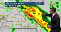
Looking ahead, Friday, April 18, 2025, is expected to bring a surge of warm air, pushing temperatures into the 60s, along with the potential for scattered showers and thunderstorms as another storm system approaches. Saturday, April 19, 2025, will likely see continued scattered showers with highs in the mid-60s before temperatures drop again on Sunday, April 20, 2025, to the upper 40s. By Monday, April 21, 2025, temperatures will rebound to near 60 degrees with a chance of late showers.
Meanwhile, Southeast Wisconsin experienced similar weather conditions on the same day, with gusty winds reaching up to 40 mph. The evening forecast indicated breezy conditions that would improve overnight, with low temperatures expected to drop around 30 degrees inland and 34 degrees near the lake. Wednesday in this region is forecasted to be chilly but sunny, with high temperatures reaching 47 degrees near the lake and 53 degrees inland.
As for the rest of the week, conditions will shift again, with showers likely late on Thursday, April 17, 2025. The high temperature for that day is projected to be 53 degrees near the lake and 62 degrees inland. Friday, April 18, 2025, is anticipated to be partly cloudy, windy, and warm, with highs reaching 68 degrees, while Saturday is expected to be mostly sunny with a high of 55 degrees.
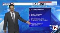
In Rhode Island and Southeast Massachusetts, showers were reported to have ended by Tuesday evening, April 15, 2025, with drier weather expected after 9 PM. The forecast for Wednesday predicts a mix of clouds and sun, with cooler temperatures and gusty winds. Low temperatures on Tuesday night are expected to fall into the upper 30s to lower 40s.
On Wednesday, April 16, 2025, the region will experience partly sunny skies, breezy conditions, and cooler temperatures, with highs in the low 50s. Winds will be from the west at 10-20 mph, with gusts potentially reaching 30 mph, making it feel chillier throughout the day. Thursday, April 17, 2025, is forecasted to be sunny and dry with temperatures in the upper 50s, continuing into a pleasant Friday.
As spring unfolds, weather patterns across the Northeast are proving to be dynamic and unpredictable. With cold fronts and warm air surges influencing temperatures and precipitation, residents are advised to stay informed through local forecasts to prepare for these rapid changes. Whether it's rain, snow, or sunshine, the weather continues to play a significant role in daily life across the region.