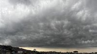
A cold front advancing over southern Brazil is set to significantly drop temperatures in Passo Fundo and the Northern Region on Easter Sunday, April 20, 2025, as well as during the Tiradentes holiday on Monday, April 21, 2025. This weather phenomenon is attributed to the movement of a polar air mass approaching the southern Brazilian territory, leading to a notable decrease in temperatures across the state, particularly in the Campanha and Serra regions.
According to Climatempo, the weather forecast for Passo Fundo on Saturday, April 19, 2025, indicates temperatures ranging from 15ºC to 23ºC, characterized by overcast skies and intermittent rain throughout the day. However, as the cold front takes hold, Sunday will see a marked drop, with temperatures expected to reach a minimum of 10ºC and a maximum of 21ºC, accompanied by heavy cloud cover and no rainfall.
In the Campanha and Serra regions, temperatures could plummet to as low as 4ºC, raising concerns about the possibility of frost. As the cold air mass lingers, Monday's forecast suggests a predominant sunny day, although the polar air mass will still affect the region. Nighttime and early morning temperatures will remain chilly, with frost anticipated in the higher elevations of the Serra.
In Passo Fundo, temperatures on Monday are expected to range between 9ºC and 22ºC, according to Climatempo. The following day, Tuesday, April 22, 2025, will mark a gradual weakening of the cold air mass, paving the way for a slight increase in temperatures. Although the mornings will still be cool, the intensity of the cold will diminish compared to the preceding days.
Meanwhile, in the Southeast region, a cold front that arrived over the weekend is maintaining unstable weather conditions during the final days of the extended Easter holiday, with storm risks in certain areas. Following heavy rains on Saturday, April 19, 2025, which triggered alerts for flooding in São Paulo, the metropolitan area, ABC Paulista, and along the coast, this cold front is now moving towards Espírito Santo and northern Minas Gerais.
According to Climatempo, areas of instability are expected to intensify throughout the day in Espírito Santo and Minas Gerais, while remaining over Rio de Janeiro. However, the heavy cloud cover is anticipated to dissipate from much of São Paulo. The sun is expected to reappear in many parts of the interior of São Paulo, although moderate to heavy rainfall is still possible near the border with Minas Gerais.
In Greater São Paulo, cloudy conditions with rain are expected at any time, albeit of weak to moderate intensity. The coastline of São Paulo will experience a cloudy day accompanied by rain and moderate to frequent maritime winds.
On Sunday, April 20, 2025, all regions in Rio de Janeiro, Espírito Santo, and Minas Gerais will see predominantly cloudy skies with rain likely at any time. Climatempo has issued warnings for a heightened risk of storms, particularly in the southern coast and North Fluminense, as well as in southern and northern Espírito Santo. Rainy conditions are also expected in the Baixada Santista and the northern coast of São Paulo. Although the chance of lightning remains low, rainfall may be moderate to heavy throughout the day.
Looking ahead to Monday, April 21, 2025, which marks the Tiradentes holiday, rain is predicted to concentrate along the Southeast coast with weak to moderate intensity, while showers will persist in the northern and eastern parts of Minas Gerais. The passage of this new cold front will usher in cold winds of polar origin across the Southeast, resulting in a drop in temperatures across all states. However, forecasts do not indicate any freezing mornings.
The afternoons are expected to be mild and pleasant, with mountainous regions and Greater São Paulo experiencing a chill throughout the day. As the holiday weekend comes to a close, residents are advised to prepare for the fluctuating temperatures and potential rain, making it essential to stay updated on weather conditions.