XALAPA, VER.- The last few months in Veracruz have been marked by a mix of warm surges and cold fronts, creating a stark contrast between heat and cold in a matter of moments. This pattern is set to continue into the second week of May, as a warm surge is expected to develop, followed by the arrival of a new cold front that will bring a drop in temperatures, rain, and a north wind event.
The Veracruz Civil Protection has activated a Special Precautionary Notice. The warm surge began on Tuesday, May 6, and will last until Thursday, May 8, generating wind gusts of 45 to 60 kilometers per hour in mountainous areas and the northern and central coasts of the state, with stronger gusts expected in regions such as Acayucan, Jesús Carranza, and the Isthmus. The heat has reached up to 45°C, with thermal sensations nearing 50°C. On May 6, the hottest locations were Tierra Blanca and El Garro in Isla, where temperatures reached 45.5°C and 44°C, respectively.
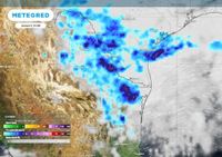
By Thursday afternoon, May 8, cold front number 42 is expected to approach the northwest Gulf of Mexico, increasing the chances of rain and storms in Veracruz, along with a stronger north wind event along the central coast. The strongest gusts, which could reach up to 80 km/h, are expected to begin at 6:00 AM on Friday, May 9, and persist until Saturday, May 10, with peak intensity around noon. By Sunday, May 11, these conditions are projected to subside.
The effects of cold front number 42 will be most pronounced between Friday and Saturday, when the heaviest rainfall is expected to occur, starting in the northern and central mountainous areas before spreading southward. During this period, a general decrease in temperatures is anticipated across the state, prompting officials to advise residents to stay updated on weather forecasts. "Meteorological conditions will undergo significant changes in the state of Veracruz, especially on Friday and Saturday when cold front number 42 will bring heavy rain accompanied by electrical activity, strong wind gusts, and possible hail," stated the SPC report.
According to the official forecast from Civil Protection, the effects of cold front number 42 in Veracruz are expected to last until Sunday, May 11. Rainfall is expected to start diminishing from Saturday in some areas, and the north wind event with its maximum gusts is also expected to decrease by Sunday.
As for the rainy season and cyclone season in Veracruz, meteorologists have confirmed that it will begin on June 1, 2025, and end on November 30, 2025. Last year, significant events in southern municipalities left lasting impacts on homes and businesses due to flooding.
Meanwhile, the National Meteorological Service (SMN) has issued alerts regarding cold front number 42, which will cause temperature drops, intense rain, wind gusts, and possible whirlwinds across various regions in northeastern Mexico, including Nuevo León. This phenomenon is expected to remain active from May 7 to May 9, 2025.
The system will start to manifest from the night of Wednesday, May 7, with its main effects anticipated on Thursday, May 8, and Friday, May 9. The SMN forecasts intense localized rains for Nuevo León on Thursday, and very strong precipitation on Friday, in interaction with a low-pressure channel and the subtropical and polar jet streams. During the passage of the cold front, minimum temperatures of up to 19 degrees Celsius and maximum temperatures of 26 degrees Celsius are expected in the metropolitan area of Monterrey. The temperature drop will extend to rural and mountainous areas, where it may be felt more acutely.
Wind gusts of 30 to 40 km/h with gusts up to 70 km/h are expected in various zones of the state, particularly in northern Nuevo León. Although no specific alert has been issued by state Civil Protection, the weather conditions could affect visibility on highways, especially due to wind gusts and heavy rain. Residents are advised to take precautions while driving and to follow official advisories during these days.
As for preventive measures, authorities typically recommend avoiding crossing flooded streets, removing objects that could fall due to the wind, securing windows and lightweight roofs, and staying informed through official channels.
The cold front number 42 is expected to dissipate over the weekend, although remnants of humidity could lead to isolated showers on Saturday, May 10. Temperatures are expected to gradually recover from Sunday onwards.
In addition, the arrival of cold front number 42 to Mexico will trigger electrical storms with strong winds and hail in several states. For Thursday, May 8, 2025, the reinforcement of cold front number 42, interacting with the Subtropical Jet Stream, will cause rains with electrical activity and even hail in the north and northeast of the country.
Intense rains (75 to 100 mm) are forecast for Coahuila, Nuevo León, and Tamaulipas, while very heavy rains (50 to 75 mm) are expected in San Luis Potosí, Querétaro, Hidalgo, Puebla, and Veracruz. Heavy rains (25 to 50 mm) are anticipated in Guanajuato, the State of Mexico, Tlaxcala, and Chiapas, and moderate rains (5 to 25 mm) in Mexico City, Morelos, Guerrero, and Oaxaca. Light rains (less than 5 mm) are expected in Baja California, Sonora, Chihuahua, Guerrero, the State of Mexico, Hidalgo, and Tlaxcala.
Wind gusts of 60 to 80 km/h are expected in Chihuahua, 50 to 70 km/h in Coahuila, Nuevo León, Tamaulipas, San Luis Potosí, Zacatecas, and Durango, and 40 to 60 km/h in Sonora, Aguascalientes, and Jalisco. Additionally, 30 to 50 km/h winds are forecast in Baja California, Baja California Sur, Sinaloa, Nayarit, Colima, Michoacán, Guerrero, Guanajuato, Querétaro, Hidalgo, Puebla, Tlaxcala, the State of Mexico, Mexico City, and Morelos.
As temperatures soar in many regions, maximum temperatures of 40 to 45 °C are expected in states like Jalisco, Colima, Michoacán, Guerrero, Morelos, Puebla, Oaxaca, Veracruz, Tabasco, Campeche, and Yucatán. Meanwhile, minimum temperatures of -5 to 0 °C are expected in mountainous areas of Chihuahua and Durango, with 0 to 5 °C in high areas of Zacatecas and the State of Mexico.
As the weather conditions are subject to change, authorities recommend that the public stay informed and vigilant regarding any developments that may occur throughout the day. Local Civil Protection will report in case of any events that may endanger citizens.