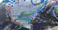
The National Meteorological Service (SMN) has issued a weather forecast for April 8, 2025, predicting significant changes across various regions of Mexico due to the influence of Cold Front 37. This front is expected to bring a cold air mass that will cover the Gulf of Mexico, the northeast, central, and eastern parts of the country, leading to showers and heavy rains in the southeastern region, particularly in the Yucatan Peninsula.
As reported, the cold front will move eastward over the Yucatan Peninsula, while the associated cold air mass will cause a considerable drop in temperatures, especially during the night and early morning hours. The SMN has also warned of a 'Norte' event, which is characterized by strong winds, affecting the coastal areas of the Gulf of Mexico, the Yucatan Peninsula, and the Isthmus and Gulf of Tehuantepec. This weather pattern is expected to persist throughout the day, resulting in chilly conditions across the northern, northeastern, eastern, and central parts of the country.
In addition to the rain and cooler temperatures, strong winds with gusts ranging from 40 to 60 km/h are anticipated in various states. The SMN has specifically noted that the Yucatan Peninsula will experience localized heavy rains, with forecasts showing potential rainfall amounts of 25 to 50 mm in Chiapas, Tabasco, Campeche, and Quintana Roo. Other regions such as Veracruz, Oaxaca, and Yucatán are expected to see intervals of showers ranging from 5 to 25 mm, while isolated rains of 0.1 to 5 mm are likely in Tlaxcala and Puebla.
Meanwhile, the Valley of Mexico, which includes Mexico City and the State of Mexico, is predicted to have a clear to partly cloudy sky with haze. There is no expected rain in these areas. Morning temperatures are expected to be cool, ranging from 5 to 7 °C in Mexico City, with maximum temperatures reaching between 24 to 26 °C during the day. In Toluca, minimum temperatures will range from 2 to 4 °C, with maximums between 21 to 23 °C.
On the same day, the SMN confirmed that Cold Front 37 would eliminate the heat wave that was initially forecasted for April 9, causing temperatures to plunge as low as -5 °C in certain areas. This front is particularly notable for generating strong wind gusts, known as the 'Norte' event, which could reach speeds of up to 100 km/h in the Isthmus and Gulf of Tehuantepec.
As of April 8, the SMN reported that the cold front would impact regions such as Chihuahua and Durango, where minimum temperatures could drop to between -10 to -5 °C in mountainous areas. Other states, including Zacatecas, Aguascalientes, San Luis Potosí, Nuevo León, Guanajuato, Michoacán, State of Mexico, Hidalgo, Tlaxcala, Puebla, Veracruz, and Oaxaca, are expected to experience temperatures between -5 to 0 °C. In areas like Sonora, Coahuila, Jalisco, Querétaro, Mexico City, and Morelos, temperatures are expected to hover between 0 to 5 °C.
The SMN also anticipates that the warm afternoon temperatures will continue in the west and south of the country, with highs of 40 to 45 °C expected in states such as Sonora, Chihuahua (southwest), Durango (west), Sinaloa, and Guerrero. Meanwhile, maximum temperatures of 35 to 40 °C are forecasted in Baja California, Baja California Sur, Nayarit, Jalisco, Colima, Michoacán, Morelos, Puebla (southwest), Oaxaca (west), and Chiapas (coast).
As the weather changes, residents are advised to stay informed about local forecasts and prepare for the conditions ahead, particularly in areas expected to experience heavy rainfall and strong winds. The SMN continues to monitor the situation and provide updates as necessary, ensuring that the public is aware of any potential hazards associated with this cold front.
In summary, the upcoming weather conditions will vary significantly across Mexico, with Cold Front 37 bringing not only cooler temperatures but also a higher likelihood of rain and wind. Residents are encouraged to remain vigilant and prepared for the changes that this front will bring.