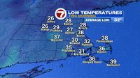
Across many regions, early morning temperatures dipped below freezing, a chilly reminder that winter isn’t quite over yet. As the sun rises on March 19, 2025, the day promises to be pleasant, with temperatures climbing into the mid-50s to low 60s for areas further inland, while coastal areas linger around 50 degrees. Although the day starts with sunshine, clouds are expected to roll in this afternoon, particularly impacting Southeast Massachusetts.
As the sun sets, low clouds will make a return, bringing a chance of patchy drizzle into the mix. It’s projected that on March 20, early morning clouds may produce some sprinkles, while the majority of the day will be dominated by a cloudy sky. Despite the clouds, temperatures remain mild for mid-March, with highs expected to settle in the upper 40s near the coastline and low to mid-50s elsewhere.
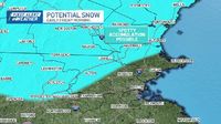
Looking ahead, the region is bracing for another storm system moving in late on March 20, extending into the early hours of March 21. This storm will primarily deliver rain to most areas, although those in higher terrain across New England should keep an eye out for the potential switch to wet snow as colder air invades from the north. Forecasters anticipate around half an inch of rain as the storm progresses.
Weather enthusiast are certainly keenly observing forecasts as the weekend approaches, with breezy conditions expected. Saturday, March 22, is anticipated to warm up into the high 50s, nearly touching 60 degrees. However, a drop in temperatures is forecasted for Sunday, March 23, when conditions are expected to spiral down into the 40s.
With warmer air moving into the region on March 19 and March 20, temperatures may sneak into the 60s for some areas away from the coast, where sea breezes will maintain milder conditions in the 50s on March 19. This weather pattern is indicative of the mixed bag of conditions that has characterized this season.
As the storm approaches on March 21, it is predicted to strengthen quickly, drawing in colder air from northern New England—a dynamic that could lead to localized snow in parts of Massachusetts and southern New Hampshire. While minor accumulations are possible as the storm travels through, the afternoon should see a shift back to warmer temperatures in the 40s as the system exits.
Meanwhile, the forecast remains active as meteorologists anticipate another storm early in the following week, around March 24, adding another layer of excitement for the forecasting community. In addition to the storm systems, pollen levels are also making a noticeable impact—though currently within tolerable limits, they are predicted to gradually rise as spring fully takes hold.
In summary, while this mid-March week has started with a chill, warmer temperatures are expected to usher in some spring-like conditions, albeit briefly, as the changing weather pattern suggests more shifty conditions ahead.