In recent years, Changsha City has witnessed an extraordinary transformation as its urban landscape has evolved significantly due to rapid construction land expansion. A comprehensive study conducted by researchers, which systematically analyzed land use changes from 2000 to 2023, revealed key insights into the drivers, trends, and implications of this expansion. The study employed three advanced classification models—Random Forest (RF), Gradient Boosting Decision Tree (GBDT), and Artificial Neural Network (ANN)—to assess land use changes with remarkable accuracy.
The findings of the study highlighted that the RF model surpassed the others, achieving an impressive accuracy rate of 95.78% in classifying land use categories. Notably, during this period, construction land in Changsha expanded nearly threefold, soaring from 563.82 km² in 2000 to an astonishing 1628.20 km² in 2023. The most significant growth was predominantly observed between 2010 and 2015, coinciding with China’s ambitious “New Urbanization” policy, which facilitated mass migration from rural areas to cities.
One of the key driving forces behind this rapid urban expansion was identified as the population growth in Changsha, where the permanent population has exceeded 10 million according to the most recent census. The researchers also determined that two significant factors—the nighttime light index and population density—were primary contributors to the increase in construction land. Both factors consistently exhibited strong correlations with land use changes across all years studied.
Projecting future growth, the study incorporated scenario analyses, estimating that under a natural development scenario, the construction land area could rise to an alarming 1920.65 km² by 2030. Conversely, the farmland protection scenario could limit the area to 1826.32 km², while the ecological control scenario suggests a more restrained expansion to 1702.66 km², signaling the potential benefits of stricter ecological protection policies.
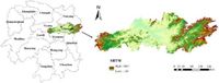
Changsha's urban landscape is shaped not just by anthropogenic factors, but also by geographic and climatic elements. The city is located in the northeastern part of Hunan Province. Its subtropical monsoon climate, characterized by an average annual temperature of approximately 17 °C and an annual precipitation around 1400 mm, applies significant pressure on land resources and has implications for both urban planning and ecological sustainability.
The research employed Landsat 5 and Landsat 8 satellite imagery, enabling long-term monitoring of land use changes and providing the necessary data for robust classification operations. This use of remote sensing technology reflects a growing trend in urban studies, which seek to understand and simulate the dynamics of urban development.
The study's conclusions underscore the importance of integrating ecological considerations into urban land use planning. Policymakers are urged to consider the significant consequences of unchecked urban expansion, which risks the encroachment of valuable agricultural land and sensitive ecosystems. The research emphasizes the crucial need for balanced approaches that reconcile economic growth with ecological preservation, thereby supporting sustainable urban development in Changsha.
The researchers hope their study will provide valuable insights for land use planning and policy formulation in Changsha and lead to a harmonious balance between urban development and environmental sustainability.