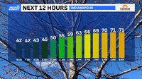
INDIANAPOLIS – Residents of central Indiana should prepare for significant changes as this week offers both the warmest day forecasted and the potential for severe storms. Tuesday, March 18, 2025, begins with clear skies and mild temperatures, offering residents the warmest day of the week, with highs projected to reach the lower 70s. Winds from the south will contribute to these pleasant temperatures, expected to gust between 20 to 30 miles per hour.
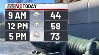
According to the National Weather Service, the temperatures this week are unusually warm, climbing roughly 20 degrees above the seasonal average. "Many parts of Indiana will see highs near 73 degrees this Tuesday," indicated forecasters. Yet, as the sun sets, clouds will build, setting the stage for the volatile weather expected on Wednesday.
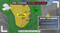
Wednesday, March 19, 2025, marks the arrival of a stronger cold front, which the National Weather Service warns could lead to severe thunderstorms across the region. These storms are forecasted to develop primarily after 5 PM, with rain chances reaching 60% and gusty winds potentially exacerbated by thunderstorms, soaring to speeds of up to 40 mph.
Weather updates predict the evening hours will bring heightened storm activity, with forecasters noting, "Thunderstorms are possible Wednesday and Wednesday night, and some could be strong or severe with all hazards possible." Residents should brace for damaging winds and possibly larger hail as storms vary throughout central Indiana.
By Thursday, the weather shifts dramatically as temperatures dip significantly, predicted to settle around the mid to lower 40s. "A cooler pool of air will settle, leading to additional rain showers, and potentially mixing with flurries," meteorologists explained, indicating this first wave of spring could juxtapose unexpected wintery conditions.
Breaking down the forecast leading up to this significant weather day, Tuesday features mild temperatures, but Wednesday will expose residents to dangerous weather fluctuations. Indianapolis will see breezy conditions continue as the storm system approaches.
The NWS has emphasized the need for residents to remain alert, especially as details progress concerning the arrival of heavy rainfall and the likelihood of severe thunderstorms. "Eyes should be on the skies, and locals are encouraged to check weather updates regularly," they noted.
The cold front arriving on Wednesday will force inhabitants to shift from pleasantly warm weather to potential stormy turmoil. Following the front, Thursday will not only be cooler but might see some residual moisture contribute to flurries. This stark temperature fluctuation is emblematic of Indiana's unpredictable springtime weather.
Further emphasizing the substantial atmospheric changes, meteorologists caution against complacency, warning, "Prevailing winds could top out between 20 to 30 mph Tuesday before reaching as high as 45 mph with the storms on Wednesday." The unpredictable nature of the upcoming weather is summarized perfectly by the NWS: "Prepare for changing conditions, and stay informed!"
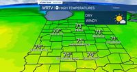
On Friday, March 21, 2025, the forecast returns to seasonally warmer temperatures, recovering to the mid-50s with dry conditions expected across the region. Following this brief respite, the weekend promises more rain, especially Saturday and Sunday, bringing another round of precipitation with potential rain showers, translating to spring's typical unpredictability.
Spring officially arrives with the equinox at 5:01 AM on Thursday, marking time for seasonal cleaning and outdoor activities. Yet, Indiana's weather holds true to its mercurial reputation with fluctuative temperatures and the likelihood of winter mixing on what should resonate as spring days.
Whether you're planning to head out on Tuesday to enjoy the warmth or preparing your emergency kit for possible severe weather, the shifting patterns this week prove to be ever-instructive about Indiana's climate behaviors. "This week encapsulates the unpredictable and tempestuous nature expected within springtime forecasting," said one meteorologist. Residents should keep those umbrellas handy, just as they have their sun hats ready – because as weather goes, it's never as simple as it seems!
With all this noted, staying proactive and informed through these upcoming weather changes offers the best path forward as we transition fully out of winter and embrace the spring season. Keeping abreast of forecasts will prepare you for everything Mother Nature may conjure next.