CEDAR RAPIDS, Iowa (KCRG) - The last few days of astronomical winter are bringing quite the weather rollercoaster for residents of Cedar Rapids as they prepare for both warm temperatures and the threat of snow and storms.
After enjoying mild weather, which has seen temperatures reach highs ranging from the upper 60s to lower 70s, locals can anticipate some changes starting on Tuesday night, March 18, 2025. Expecting pleasant conditions with just occasional clouds, the warmth will be short-lived as winds begin to pick back up, gusting up to 30 mph.
While the cool night temperatures will linger, with lower ranges touching the upper 30s to low 40s, parts of the area to the southeast of Cedar Rapids will remain warmer, experiencing lows reaching the upper 40s to low 50s. This transitional weather is primarily due to the anticipated storm system approaching from the southwest.
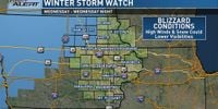
By Tuesday night, some showers are expected to develop, with the possibility of small hail appearing during these storms. Notably, the National Weather Service has issued a Winter Storm Watch for parts of the area, signaling upcoming significant changes.
On Wednesday, March 19, the weather will transition more drastically as temperatures will dictate the form of precipitation. Scattered showers will be predominant during the day, but as colder air moves in during the afternoon, places across northern and northwestern counties will start to see rain switch over to snow by mid-afternoon.
Residents can expect stormy conditions especially affecting areas east of a line drawn from Mt. Pleasant to Cedar Rapids and reaching to Dubuque. There’s potential for strong storms during the daylight hours, particularly between 11:00 AM and 5:00 PM. "Difficult to impossible travel is expected in northern and western Iowa," noted meteorologists, emphasizing the impact of approaching weather systems.
Winds are forecasted to increase significantly on Wednesday, with gusts peaking around 45 to 55 mph, leading to challenging conditions and possibly blizzard-like circumstances for those within the watch areas. This mixture of falling snow, high winds, and visibility issues may complicate travel considerably as the storm progresses.
It’s advised for anyone with travel plans toward northern and western Iowa to reconsider or adjust their schedules, keeping problems like slick roads and low visibility top-of-mind. Accumulation totals for snow particularly to the west of Cedar Rapids may lead to significant blowing and drifting, resulting in hazardous conditions.
Looking beyond the storms, Thursday will bring about some respite, though winds will still be present. Forecasts predict lows dipping to the 20s, but daytime highs should rebound to the mid-40s, aiding in melting any snow accumulation.
On Friday night, there is the likelihood of the arrival of another weak storm system which may introduce light rain showers, and only minimal snow mixing, as the system lacks moisture depth.
Throughout the weekend of March 22-23, typical late March weather will return with lows maintaining the 30s and highs climbing to the 50s, alongside potential rain showers returning late on Sunday.
Looking ahead to the following week, typical late March conditions will dominate the area with temperatures hovering between the upper 20s and low 30s at night, and daytime highs reaching up to the mid-50s under partly to mostly sunny skies. Weather patterns are showing signs of remaining steady just beyond the significant changes this week.