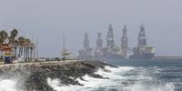
The Government of the Canary Islands, in collaboration with the State Meteorological Agency (AEMET), declared a pre-alert situation for coastal phenomena across the archipelago on Saturday, April 19, 2025, starting at 16:00 hours. This decision follows forecasts predicting significant swell and intense winds, with waves potentially exceeding three meters in certain coastal areas, particularly along the southeast and northwest coasts of the islands.
AEMET reported that northeast winds would reach force 5 to 6 (between 29 and 49 kilometers per hour), with gusts of force 7 (between 50 and 61 kilometers per hour) expected, especially offshore between the islands and along the northern and northeastern coasts. These conditions are anticipated to create strong swells, with combined seas ranging from 2 to 3 meters. As a precaution, the Government has activated preventive measures in port areas, coastal access points, and urban areas adjacent to the sea.
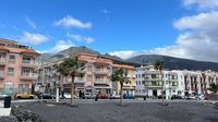
On Sunday, April 20, 2025, the weather in the Canary Islands will be characterized by cloudy skies, particularly in the northern regions of the larger islands, with weak and occasional rain expected mainly in mid-altitude areas during the morning. The AEMET forecasts slight changes in temperatures, with minor increases in maximum temperatures on peaks, which may offset the reduced thermal sensation due to humidity and wind. The maximum temperature in Tenerife is expected to reach 24 degrees Celsius, while El Hierro will see the lowest minimum at 12 degrees Celsius.
Moreover, there is a low probability of weak frost in the high central peaks of islands like Tenerife and La Palma. Winds will remain moderate from the northeast but are expected to increase in intensity during the afternoon, especially on the east and northwest slopes, where very strong gusts are likely.
Gran Canaria is under a yellow warning for winds, with forecasts indicating moderate to strong northeast winds that will increase in force on the southeast and western slopes, as well as in the summits and mid-altitude areas of the south and west, where very strong gusts could be recorded. La Gomera is also under a yellow warning, with similar conditions expected.
In San Sebastián de La Gomera, temperatures are projected to reach a maximum of 23 degrees and a minimum of 17 degrees, indicating a stable thermal environment contrasting with the dynamic atmospheric conditions. For Lanzarote and Fuerteventura, moderate winds with strong intervals from the northeast are expected, particularly in the late afternoon. In Fuerteventura, strong gusts are likely, especially in the southern and inland areas, which, combined with significant wave activity, could impact fishing activities, maritime excursions, and coastal tourism. Temperatures in Puerto del Rosario and Arrecife are anticipated to range between 16 and 23 degrees Celsius.
AEMET has reiterated the need for heightened caution in maritime environments, advising restrictions on access to exposed breakwaters and beaches, and recommending the postponement of nautical or outdoor sports activities. Public cooperation in adhering to these recommendations is crucial to prevent incidents.
The Government of the Canary Islands will maintain the pre-alert status as long as the risk situation persists, updating information as atmospheric conditions evolve. Authorities are coordinating with Maritime Captaincies and emergency services to ensure the safety of residents and tourists.
On the ground, the pre-alert has not resulted in significant incidents during the day, although particularly intense gusts were recorded overnight in some areas, such as El Pinar in El Hierro. Winds have also been felt in La Palma and Gran Canaria, where rough seas were noticeable.
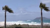
Despite the adverse weather, many residents flocked to Candelaria, Tenerife, for a day at the beach, only to be greeted by wind and cloudy skies instead of sunshine. In La Laguna, the sun failed to make an appearance, prompting many to don coats and grab umbrellas. Winds have exceeded 75 kilometers per hour in various parts of the Canary Islands, with El Pinar recording a peak of 83 kilometers per hour early on April 20.
The AEMET's forecasts have become the primary source for planning safety measures and civil protection in the islands, particularly in anticipation of adverse weather phenomena like those expected this weekend. The government continues to monitor the situation closely, ready to elevate warnings should conditions worsen.
As the Canary Islands brace for these challenging weather conditions, the focus remains on public safety and preparedness. The collaboration between government agencies and the community is vital in navigating the potential impacts of this weather system.