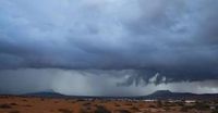
The Canary Islands are bracing for a significant change in weather as the State Meteorological Agency (Aemet) has predicted the approach of a DANA (Depresión Aislada en Niveles Altos), which is expected to bring intense rains, strong storms, and possible haze starting Friday, March 28, 2025. This weather event will particularly affect the westernmost islands, including La Palma, El Hierro, and La Gomera.
On Friday, residents can expect cloudy skies with occasional light rain in the north of Gran Canaria and more substantial showers in the western islands. According to Aemet, the rainfall may be persistent or moderate in La Palma, El Hierro, and La Gomera, while the northern slopes of Tenerife and Gran Canaria will also see some precipitation. However, no rainfall is forecasted for the eastern islands of Lanzarote and Fuerteventura.
The weather forecast indicates that temperatures will remain relatively stable, with maximums expected to reach around 22 degrees Celsius in Tenerife and a minimum of 11 degrees in El Hierro. Winds will initially blow from the northeast but are expected to shift to the west and south by Saturday. Aemet has advised that the rain in mountainous areas may persist, although it is not anticipated to be excessively heavy.
As the weekend approaches, the situation may worsen, particularly in the western islands. Aemet has issued yellow warnings for El Hierro and La Palma due to the potential for heavy rainfall, which could reach up to 20 millimeters in one hour. These warnings will take effect at 3:00 PM on Saturday and are expected to last until noon on Sunday, March 30, 2025.
In El Hierro, the warning encompasses the entire island, with the agency noting that the heaviest rainfall is likely in the interior regions. Similarly, La Palma's warning covers both the eastern and western slopes as well as the peaks, where thunderstorms may accompany the rain.
Friday's weather will start with cloudy intervals, predominantly in the central hours of the day. Rain is expected in the north, particularly in the midlands of the eastern islands, where it will be weak and occasional. In La Palma and El Hierro, however, the possibility of heavy showers in the afternoon cannot be ruled out. The temperatures will experience a slight decrease in the southern midlands and peaks, while remaining stable in other areas.
In the province of Las Palmas, the weather forecast highlights that the northern region of Gran Canaria will be cloudy with occasional light rain, transitioning to partly cloudy in the afternoon. Meanwhile, Lanzarote and Fuerteventura will see partly cloudy to clear skies with some morning cloudiness and a chance of light haze. The temperatures are expected to remain relatively unchanged, with highs around 22ºC in Las Palmas de Gran Canaria and lows of 17ºC.
As for the wind, it will initially be moderate from the northeast, becoming lighter and variable later in the day. The changing weather conditions are attributed to the DANA, which is likely to enhance cloudiness and rainfall across the islands.
Looking ahead to Saturday, March 29, the weather may further deteriorate, especially in the western islands, where strong storms could develop by the end of the day. While Lanzarote and Fuerteventura may maintain clear skies, the rest of the archipelago is expected to see increased cloud cover and significant rainfall beginning around noon.
Temperatures are predicted to rise slightly on the northern and eastern slopes, with this increase being more apparent in the midlands of the central islands. Winds will shift to a westerly direction in the eastern islands and will blow from the southwest in Gran Canaria. In the western province, winds will come from the south, transitioning to the southwest throughout the afternoon.
Aemet has emphasized the need for caution and recommends monitoring weather updates throughout the weekend due to the potential for adverse conditions. This follows the recent passage of two storms, Konrad and Martinho, which had already left their mark on the region with strong waves, rain, and wind.
As residents prepare for the weekend, they are advised to stay informed about the evolving weather situation, particularly those in the western islands where the impact of the DANA is expected to be most pronounced. The agency's warnings highlight the unpredictable nature of weather in the Canary Islands, especially during this time of year.