The city of Boston is experiencing a varied weather pattern, starting with a dense fog advisory that was issued by the National Weather Service Boston/Norton MA. In a statement obtained by NWS, visibility may be reduced to "one quarter mile or less at times in dense fog" affecting eastern Massachusetts including the Cape and Islands until 10 a.m. EDT on March 20. Motorists are advised to "slow down, use your headlights, and leave plenty of distance ahead of you" to navigate the hazardous driving conditions.
According to today's forecast from NWS, temporary relief from the fog is expected with "areas of drizzle before 10 a.m." and a high near 54 degrees. However, the weather is set to shift as "rain is likely, mainly after 3 a.m." on March 21, with a 60% chance of precipitation and a low around 43 degrees. Heading into Friday morning, commuters should expect additional precipitation amounts between a tenth and a quarter of an inch, with speculation of wet snowflakes during peak travel hours.
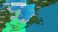
The weekend is forecasted to bring a brief respite, as NWS predicts Saturday will be "mostly sunny," with temperatures reaching the high 50s. Yet true to the New England weather roller coaster, a plunge back into the 40s is expected by Sunday. This prevailing dance between seasons continues into next week with a chance of snow Monday morning transitioning back to rain, and uncertain precipitation peppered throughout the following days, maintaining a pattern of meteorological fickleness.
Amidst these unpredictable conditions, NBC Boston reported that on March 21, "the rain won’t last all day, but we’ll get a solid shot of it during the morning commute," and even as the storm clears, Boston's residents should brace for brisk winds with gusts hitting up to 40 mph as the skies clear into afternoon sunshine.
Boston's weather history is not unfamiliar with such unpredictable changes, making the populace adept at riding the waves of varying weather patterns. For Friday, March 21, NWS indicates that a system pushed through New England overnight bringing a burst of rain to Boston. As today unfolds, the morning commute will likely see steady to heavy showers, especially in Boston and coastal New England, while areas from Vermont down through Western Massachusetts will experience clearing conditions.
By lunchtime, the storm is expected to move out, allowing dry air to settle into the region bringing back the sunshine. Afternoon highs are projected to reach the mid- to upper 40s, but winds will pick up significantly, intensifying the chill to make it feel closer to 40 degrees. Gusts are predicted to build to around 15 miles per hour, with potential gusts reaching 30 to 40 miles per hour. As is typical, these winds will persist into Friday evening, creating a brisk atmosphere.
As Saturday, March 22, approaches, the forecast points to a beautiful weather day to follow. The sun is expected to shine brightly, with many areas reaching temperatures of 60 or 61 degrees by afternoon, particularly along the coast. Although this pleasant weather is forecasted, a weak cold front will traverse New England Saturday evening, possibly bringing a brief shower before temperatures dive again on Sunday, March 23.
On Sunday, highs are likely to stall in the mid-40s under mostly clear skies, and for many, cooler temperatures might entail a noticeable bite in the air. Sunset for March 23 is slated for 7 p.m., a bright note in light of the otherwise cold conditions.
As the weather pattern remains active heading into next week, a storm system is expected to arrive late Sunday night, likely introducing light rain, before temperatures drop below freezing. Snow could potentially fall across parts of Northern New England’s mountainous regions, particularly in northern Massachusetts and southern New Hampshire, as the weather makes its way into Monday, March 24.
The overnight dip into freezing marks the first time temperatures will fall below this mark since March 9. While snowfall is anticipated, accumulations are likely to remain light. Monday morning could see scattered showers alongside some spots picking up over a half inch of rain through the day.
Weather patterns this time of year can test even the most seasoned New Englanders, but with a variety of weather expected, residents should prepare for quickly changing conditions. From dense fog to rain, and potentially back to snow, the forecast serves as a stark reminder that spring in New England is often not a straightforward affair.
On a final note, many across the region are reminded to keep umbrellas at hand and to tread carefully through the changing weather conditions that the region is used to navigating each spring.