The Storm Lake area is preparing for severe winter weather as the National Weather Service has issued a blizzard warning starting early Wednesday, March 19, 2025. The warning extends until the evening, affecting most of the region, excluding only the far eastern parts of the state.
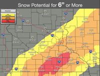
Forecasts predict snowfall totals ranging from four to nine inches, with some isolated areas potentially receiving up to 12 inches. Accompanying this snowfall will be high winds, with gusts forecasted to reach as high as 60 miles per hour. Meteorologists warn of significant hazards, including travel difficulties and whiteout conditions, making it imperative for residents to limit travel to emergency situations only.
National Weather Service updates suggest hazardous driving conditions will prevail, particularly during the Wednesday morning and evening commutes. Visibility may be severely reduced due to blowing snow, and tree damage is expected from the high winds. Those needing to travel are advised to carry winter survival kits and to remain with their vehicles if stranded. Regular updates on road conditions can be accessed at 511ia.org.
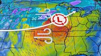
Further south, the winter storm named Winter Storm Nyla is currently bringing snowfall to the Rockies and is expected to impact the Plains and upper Midwest by tonight. This system has already left parts of California's northern Sierra Nevada with around a foot of snow on Monday, March 17, 2025, showing significant strength.
Weather alerts are widespread across the Plains, extending blizzard warnings from northwest Kansas through central and eastern Nebraska and western Iowa, including cities such as Omaha and Sioux City. Enhanced warnings have been issued for the Upper Peninsula of Michigan and southeastern Minnesota, where conditions may deteriorate rapidly as the storm progresses.
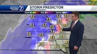
Timing of the storm indicates snowfall will intensify from March 18 to March 19. On Tuesday, snowfall is likely to begin moving eastward, affecting areas like South Dakota, Nebraska, and parts of Iowa. Various cities may experience transitions from rain to snow, initially causing slippery conditions before heavy snow arrives.
By Wednesday morning, blizzard conditions are expected, especially between 7 and 9 AM, when precipitation changes from rain to snow. Snow will accumulate at rates of one inch per hour or more and should persist through the afternoon. For regions from Omaha to parts of Minnesota, predicted snowfall ranges from three to six inches with more intense bands contributing to localized higher totals. Travelers can expect conditions to worsen significantly throughout the day, underscoring the need to avoid travel.
The National Weather Service urges residents to heed local alerts and to remain vigilant about changing weather patterns. The combination of snow and wind is anticipated to pose severe safety risks, potentially resulting in power outages due to downed trees and lines.
Residents are reminded to take precautions against the winter storm’s effects, which are significant and wide-reaching. Emergency services will be on hand to assist those who find themselves impacted by the storm. Motorists are strongly encouraged to plan for their safety and stay informed as conditions evolve.
Overall, this winter storm is shaping up to be one of noteworthy impact, warranting attention and respect for its potential dangers. Whether residents are facing severe conditions or merely preparing for them, recommendations are clear: safety first.