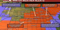
Blizzard conditions coupled with ferocious winds battered Nebraska on March 19, 2025, causing hazardous travel and widespread disruptions across the region. Residents were warned to stay indoors as heavy snow and lightning from a rapidly intensifying low-pressure system descended upon the area. As the storm progressed, reports indicated driving conditions rapidly deteriorating in many areas, predominantly where snowfall accumulation exceeded two inches.
The snowstorm resulted in blizzard warnings across Nebraska, with maximum gusts recorded at up to 70 mph in some regions. From early in the day through the afternoon, meteorologists advised people to remain cautious, emphasizing that anywhere experiencing two or more inches of snow was likely to face significant threats due to wind speeds sustained between 35 to 50 mph, with gusts peaking at over 65 mph.
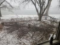
In Omaha, the heavy, wet snow began to accumulate, leading to near whiteout conditions that persisted into the afternoon. Local authorities recommended that residents avoid travel as conditions were set to worsen before any improvement was anticipated in the evening. As of mid-afternoon, neighborhoods in Omaha were still facing substantial snowfall, but it was projected that by the evening commute, snowfall would taper off significantly.
“If you have the option to stay home today, please stay home today!” pleaded meteorologists whose warnings were echoed throughout various news outlets.
Along with the snowfall, numerous weather-related impacts were observed, including fallen tree limbs and a traffic signal down at the intersection of 14th Street and Pine Lake Road. By early afternoon, substantial concerns arose about potential power outages as gusty winds wreaked havoc, lifting not just tree limbs but threatening electrical infrastructure across the area.
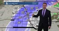
The National Weather Service highlighted that expected snowfall totals would vary significantly. In the Omaha metropolitan area, projections estimated about 4-8 inches of snow who were experiencing heavier snow bands, specifically in the western half of Douglas County. Communities south and east of Omaha would see lower totals, with expectations dropping to about 2-5 inches.
Blizzard warnings were effectively in place until 2 PM for most of Nebraska, with portions remaining under warning until later in the evening. In areas near Lincoln, a blizzard warning was specifically noted to continue until 10 PM, while a snow emergency was declared in the city due to worsening road conditions.
Despite the heavy snowfall, there was some light at the end of the tunnel as forecasters predicted that temperatures would manage to rise above freezing by the afternoon, creating some melting potential. However, this brief respite would soon be followed by a significant drop in temperatures overnight into Thursday morning, with lows plunging into the teens.
The transition into spring, albeit briefly, could offer some relief as temperatures were expected to warm back up into the 50s and 60s by the end of the work week. The weekend forecast suggested continuing warm weather with possible sporadic light rain and cloudy skies on Friday, heating temperatures to the upper 50s and low 60s.
Rounding out the week, meteorologists indicated that dryer weather could persist into the following week, with temperatures consistently in the 60s and 70s predicted. Towards the end of March, weather models hinted at the arrival of another storm system potentially bringing additional rain chances to an area still reeling from the recent blizzard.
As this winter storm unveiled its ferocity, it served as a potent reminder of the unpredictable nature of weather in Nebraska during transitional seasons.