The weather forecast for the coming days indicates a mix of conditions across the Benelux region, with changeable weather expected early in the week before a high-pressure system brings stabilization.
As the workweek begins, a high-altitude low near the Benelux will create a rather unsettled weather pattern. This will bring about some sharp showers, potentially accompanied by thunder. On Monday, April 21, 2025, a small low-pressure area will be situated above the Benelux, leading to increased instability and the likelihood of showers in the afternoon. Temperatures will rise to around 11 degrees Celsius on the Wadden Islands and between 13 to 17 degrees Celsius elsewhere.
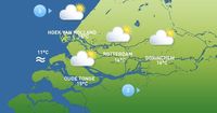
Tuesday, April 22, 2025, is forecasted to start with low clouds and local fog, but as the day progresses, the sun will make more frequent appearances. The afternoon will see a mix of sunny periods and some clouds, with a slight chance of a local shower. Maximum temperatures are expected to climb between 15 and 18 degrees Celsius, with a light to moderate southwest wind.
On Wednesday, April 23, 2025, a new high-altitude low will push towards the region from the west, again increasing variability in weather conditions. The day will begin with broad clearings in the northeast, while the southwest will experience heavy cloud cover and rain. As the precipitation zone moves northward, the northern regions could see sharp showers, possibly with thunder. Highs will range from 14 to 17 degrees Celsius in the north and 11 to 14 degrees Celsius further south.
Thursday, April 24, 2025, is expected to be marked by lingering precipitation, with predominantly cloudy skies and occasional light rain. Temperatures will hover between 10 and 15 degrees Celsius. If the precipitation zone shifts eastward quickly, there may be periods of dry weather with alternating clearings and clouds.
By Friday, April 25, 2025, the arrival of a new high-pressure area will gradually improve the weather. The day will start with broad clearings in the west, while some cloud cover remains in the east. Overall, it will become sunnier with maximum temperatures ranging from 10 to 17 degrees Celsius.
The weekend of April 26 and 27, 2025, is looking promising, with predominantly sunny and dry spring weather expected. Some weather models suggest a chance of showers over the weekend, but temperatures are anticipated to rise between 15 and 20 degrees Celsius, making it ideal for outdoor activities.
Looking ahead, the weather forecast indicates a drying trend as the weekend approaches, with an increase in temperatures. However, the long-term outlook remains uncertain as we transition into the convective season, which could lead to localized showers due to small-scale low-pressure systems.
In the Rijnmond area, the weather on April 22, 2025, will begin gray but will gradually clear up, allowing for more sunshine in the afternoon. The maximum temperature for the day will reach around 16 degrees Celsius, which is typical for this time of year. The sun is expected to set at 20:52. Tonight, conditions will remain clear and dry, cooling down to about 7 degrees Celsius.
Tomorrow, April 23, 2025, will see a shift as dominant cloud cover moves in from the south, bringing showers in the morning, possibly with thunderstorms. The afternoon temperature will remain steady at 16 degrees Celsius with little wind.
Thursday will bring more variability, with rain or showers and a drop in temperature to around 14 degrees Celsius. However, by Friday and into the weekend, the forecast suggests an improvement with sunny periods and dry conditions, with temperatures climbing towards 20 degrees Celsius in time for the Koningsweekend.
Overall, while the early part of the week will be marked by changeable weather and some precipitation, the latter part promises a transition to more stable and warmer conditions. The forecast highlights the typical unpredictability of spring weather in the Benelux region, where conditions can shift rapidly.