As Britain braces for an impending Atlantic storm, weather models predict a combination of snow and rain set to sweep across every corner of England and Wales. According to recent data from WXCharts, the storm is anticipated to engulf the British Isles on the afternoon of Saturday, March 29, 2025. This significant weather event has already prompted warnings from the Met Office, highlighting the likelihood of wetter, more unsettled conditions as March draws to a close.
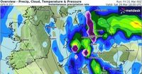
On noon that Saturday, it's expected that heavy rain will lash large swaths of Wales and the southeast, eventually moving northward. Key cities likely to face significant downpours include Plymouth, Cardiff, Southampton, Berkshire, Worcester, and Birmingham. Meanwhile, areas such as northern Gwynedd in Wales are forecast to see snowfall, adding a chilly twist to the already tumultuous weather.
The storm's impact doesn't stop there. Flurries of snow are predicted to blanket regions that include Powys, Shropshire, and Greater Manchester, alongside parts of Huddersfield, Bradford, and the Yorkshire Dales. WXCharts’ projections suggest that rain will persistently drench vast areas across both England and Wales, affecting places like Liverpool, Bolton, South Wales, London, Luton, and much of Somerset. Even the coastal towns aren't likely to escape the storm unscathed, with Eastbourne, Hastings, and Folkestone forecasted to fall within the storm's path.
In its long-range forecast for March 26 until April 4, the Met Office pointed out that while the beginning of this period may see drier weather, more changeable conditions could take over later. The organization stated, "The final week of March into the start of April looks to be characterised by a slowly evolving, but changeable weather pattern. Initially, a dry interlude is likely with spells of sunshine across many areas." However, these drier conditions will make way for more showers, especially in the north and northwest, where windier spells and a chance of gales may also develop.
Following a brief spell of warmer weather that brought temperatures up to 20 degrees Celsius earlier this month, forecasts indicate a jump back into more mixed conditions over the weekend. Saturday is projected to start cloudy with hints of sunny spells, but the likelihood of heavy showers—some potentially thundery—will soon make an appearance. As for Sunday, predictions suggest a "rather changeable" day with rain expected to dominate, including longer spells that could be heavy at times.
With all these factors at play, the forthcoming Atlantic storm serves as a stark reminder of the UK's unpredictable weather patterns as spring begins to unfold. Residents are encouraged to stay informed and prepared as they brace for this wave of winter weather, which is expected to disrupt daily life and travel plans, especially in regions more prone to heavy rain and snowfall.
As we move through the end of March and approach early April, the public should expect continued weather variability, as the Met Office hints at ongoing adjustments to weather forecasts dependent on evolving atmospheric conditions. Thus, the storm marks a significant shift in the UK’s weather narrative, one that could dominate discussions and news cycles in the week to come.