Residents of Arkansas are bracing for another round of severe weather following the devastating tornadoes over the weekend, which resulted in three deaths and significant property damage across the state. On March 15 and 16, 2025, six tornadoes touched down, including two EF-4 twisters, as reported by the National Weather Service’s Little Rock office.
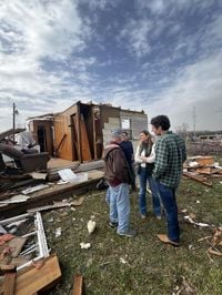
The storms resulted from conditions ripe for severe weather, including high winds and moisture, leading to tumultuous conditions across the state. The aftermath has left communities grappling with loss and destruction as officials scramble to assess the damage. The deadliest tornado struck Cushman, where it wreaked havoc, leading to three fatalities when it devastated the small town with winds estimated at 165 mph.
Governor Sarah Huckabee Sanders arrived at the storm-affected area on Saturday, March 15, pledging state support for recovery efforts. “We’ll take care of people first and worry about the paperwork later,” she stated during her visit to Cave City, which was also severely hit. The governor also announced the release of $250,000 from state disaster relief funds to assist with the recovery.
According to the latest National Weather Service data, the first EF-4 tornado, which registered peak winds of 170 mph, formed southwest of Fifty-Six before sweeping through Izard County, causing extensive damage. The second EF-4 tornado started near Oil Trough and traveled through Jackson County, demonstrating sustained winds of 190 mph over 14.5 miles.
The Arkansas Public Safety Department reported 32 injuries stemming from the storms, affecting 16 counties statewide, including Baxter, Clark, Independence, and others. This unprecedented weather event is noted to be the first time since 1997 when two EF-4 tornadoes struck Arkansas on the same day.
Additional reports confirmed the touch down of other tornadoes during the same period, including EF-1 and EF-2 tornadoes, which caused varying levels of damage from property destruction to downed power lines. An EF-1 tornado with 100 mph winds struck near Gamaliel, leading to damage to local infrastructure before progressing toward Missouri.
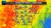
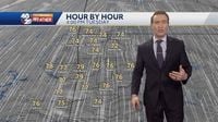
The weather conditions are not expected to improve soon, with meteorologists forecasting more turbulent weather. “Tuesday, March 18, will see winds picking up with gusts reaching 40 to 45 mph across Northwest Arkansas (NWA) and 35 to 40 mph in the river valley,” commented Chief Meteorologist Darby Bybee. On Wednesday, March 19, the forecast indicates another front will sweep through, leading to lower temperatures.
Though current weather conditions may improve slightly on March 17, meteorologists warn residents to be prepared for windy conditions, raising concerns about fire risks. Fire weather warnings issued over the weekend might be reissued as humidity rises but winds remain strong.
Wednesday, dubbed 'flip flop day' by locals, is characterized by the warmest temperatures occurring early, followed by significant cooling throughout the day. Predictions are set for high temperatures near 50 degrees Fahrenheit by the afternoon. There are also chances for light showers on March 19, but those are not expected to bring considerable rain.
Looking forward, severe weather could re-emerge toward the weekend, as meteorologists warn of the possibility of thunderstorms arriving on March 22, particularly on Sunday afternoon. The state remains vigilant as communities continue their recovery efforts from the initial storm damage.
With businesses and residents working together to restore normalcy, all eyes are on the sky as Arkansas faces another weather challenge. The coming days will be closely monitored by local officials and emergency management teams, ensuring resources are distributed where needed.
The swift response from state officials, alongside community determination to rebuild, highlights the resilience of Arkansans amid nature's fury. Only through unity and preparedness can they navigate the challenges posed by such unpredictable weather patterns.