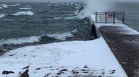
After a weekend filled with warm spring temperatures and blooming flowers, South Korea was taken by surprise as unseasonably cold weather swept across the nation from Saturday, April 12, 2025, through Monday, April 14, 2025. This sudden shift brought strong winds, rain, and even snow to various regions, leaving many residents wondering about the abrupt change.
As the cold front continued into Tuesday, April 15, 2025, strong winds persisted, causing disruptions throughout the country. Eastern areas of Gyeonggi Province, along with inland and mountainous regions in Gangwon Province, recorded snowfall accumulations of up to 5 centimeters over the weekend. In Jeju Island, strong wind advisories led to flight cancellations and a reported 52 safety incidents, including fallen traffic signs and broken windows, as of Monday.
Nationwide, high temperatures only reached 8 degrees Celsius by Monday, a stark 18-degree drop from the previous week, according to the Korea Meteorological Administration. The agency attributed this extreme weather to a cut-off low-pressure system situated in the upper atmospheric layer. Such systems occur when the jet stream flows in a highly wavy pattern, trapping Arctic cold air and causing significant temperature differences between the upper and lower atmospheric layers.
The Korea Meteorological Administration explained that the cut-off low-pressure system can create a temperature difference of 40 to 50 degrees Celsius, leading to destabilization in the atmosphere. This destabilization often results in strong wind gusts, rain, and even thunderstorms. Additionally, atmospheric blocking, which was responsible for Korea's prolonged cold waves this winter, preceded the cut-off low. This phenomenon occurs when low and high-pressure systems become stationary in the upper atmosphere, disrupting the normal west-to-east flow of weather systems.
While cut-off lows and atmospheric blocking are natural atmospheric processes that can occur at any time of year, some meteorologists have noted that these blocking events may become more frequent due to climate change. On Tuesday, however, the weather began to clear as a high-pressure system moved along the southern coast of Jeju Island. Despite the clearer skies, average temperatures remained 2 to 8 degrees lower than those of the previous year, with wind gusts reaching up to 55 kilometers per hour.
Looking ahead, as warm southwesterly winds begin to flow into the Korean Peninsula along the high-pressure system, temperatures are expected to return to previous years’ averages starting Wednesday, April 16, 2025. The forecast indicates low temperatures ranging between 1 and 10 degrees Celsius, while high temperatures are expected to range from 18 to 26 degrees Celsius.
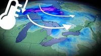
Meanwhile, in northern Michigan, a late-winter storm has been forecasted to impact the region through Tuesday morning, April 15, 2025. The National Weather Service issued a winter storm warning for the western Upper Peninsula, including areas like Ironwood, Houghton, and the Keweenaw Peninsula. Other regions are under weather advisories or hazardous weather outlooks.
Strong winds, heavy snow, and potential power outages are anticipated as the storm system strengthens over the Upper Great Lakes. The forecast predicts total snow accumulations between 2 and 9 inches, particularly in areas south of Painesdale in the Keweenaw and the interior regions of Ontonagon and northwest Gogebic counties. Winds are expected to gust up to 45 mph, creating hazardous driving conditions and possibly leading to downed trees and power lines.
As of Monday, April 14, 2025, more than 5,000 customers in northern counties were still without power due to a previous ice storm that left nearly 1 inch of ice on trees and power lines, causing widespread outages. The Marquette National Weather Service office confirmed that the winter storm warning would remain in effect until 11 a.m. Tuesday, with snow tapering off by morning and highs reaching the mid-30s.
In Sault Ste. Marie, rain is expected to transition to snow overnight, with about an inch of accumulation likely by Tuesday morning. The Gaylord NWS office has advised that rain will change to snow, with the potential for a couple of inches of accumulation across the northwest snowbelts. Wind chills could feel as low as 17 degrees in Cadillac, while temperatures will drop to the upper 20s overnight.
Further south, a cold front is also expected to bring below-normal temperatures to the region. On Monday, April 14, 2025, temperatures were forecasted to reach the upper 60s ahead of the cold front, with scattered rain showers and strong winds expected later in the day. The National Weather Service has urged residents to be weather aware and have multiple ways to receive warnings, especially as strong winds could make driving hazardous.
In southern Ontario, the weather is also taking a turn. Despite enjoying a weekend of mild spring weather, the region is bracing for more snow flurries and gusty winds through mid-week. A reinforcing shot of Arctic air is expected to keep temperatures below seasonal averages through the Easter long weekend.
Areas along Highway 11 north of Lake Superior could see as much as 10-15 centimeters of spring snow through Tuesday, April 15, 2025. Meanwhile, southern Ontario will experience isolated rain showers on Monday, with colder air returning as the cold front moves through, leading to gusty conditions and lake-effect snowfall.
Wind gusts across southern Ontario are expected to reach 50-60 kilometers per hour, with exposed regions along Lake Huron potentially experiencing gusts near 70 kilometers per hour. As the week progresses, temperatures are predicted to gradually recover, but the cold air will linger into the Easter weekend, reminding residents that winter has not yet fully relinquished its grip.