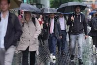
As the UK braces for a weekend of severe weather, the Met Office has issued a series of amber and yellow warnings signaling thunderstorms, heavy rain, and potential flooding across much of the country. From the southeast of England to the Highlands of Scotland, residents are being urged to prepare for what forecasters describe as some of the most intense weather conditions seen this year.
On Friday, June 13, 2025, the mercury is expected to soar, with temperatures reaching up to 30C (86F) in parts of eastern England, including Norwich, potentially making it the hottest day of the year so far. This heat comes with a caveat: the warmth is accompanied by rising humidity, setting the stage for "beefy showers" and thunderstorms that could bring substantial downpours and gusty winds.
The Met Office issued an amber weather warning for thunderstorms from 8pm on Friday through to the early hours of Saturday, affecting a swath of eastern and south-eastern England stretching from Eastbourne in Sussex up to Cromer in north Norfolk. Within this zone, some areas may experience 30-50mm of rain in just a few hours, alongside winds exceeding 40-50mph and frequent lightning strikes. The forecaster warns of power cuts and flooding of homes and businesses, with fast-flowing or deep floodwater likely to cause danger to life.
Deputy Chief Meteorologist Tony Wisson highlighted the risks: "With much of the rain falling in a short space of time there is a risk of impacts such as surface water flooding. Frequent lightning, gusty winds and hail could pose additional hazards." He also noted the uncertainty about the exact location and intensity of the storms, cautioning that updates would follow as forecasts become clearer.
Meanwhile, yellow thunderstorm warnings cover a broader area, including the south-west and south-east of England, Wales, and the West Midlands on Friday, extending into most of Scotland, the East Midlands, and northern England on Saturday. The yellow alerts indicate a small risk of power cuts, flash flooding, hail, and communities being cut off due to flooding or damaged transport infrastructure.
Scotland, in particular, faces a challenging weekend. The Met Office has issued yellow weather warnings for thunderstorms across the central belt, the Scottish Borders, Tayside, Fife, and parts of the Highlands, with the warnings active from midnight Saturday until 6pm. The Scottish Environment Protection Agency (SEPA) has also issued multiple amber flood warnings starting Saturday morning, citing potential surface water flooding, disruption to travel, and property flooding.
STV meteorologist Sean Batty described Saturday as "the most unsettled day," with widespread torrential downpours and thunderstorms especially in central, southern, and eastern Scotland. He warned that some areas could see as much as 30mm of rain in just a few hours—equivalent to two weeks' worth of rainfall for parts of eastern Scotland. Rainfall in some locations could reach 60-80mm, accompanied by strong gusts and hail.
The Met Office advises residents to prepare for sudden flooding, difficult driving conditions, and possible road closures. Public transport services may face delays or cancellations, and some communities could become temporarily cut off. They urge people to secure outdoor items, prepare flood plans and emergency kits, and check on vulnerable neighbors.
The UK Health Security Agency (UKHSA) has issued its first yellow heat-health alert of the year, covering the east of England, East Midlands, London, and the South East from Thursday night through Sunday morning. The alert warns of increased healthcare demand, particularly among vulnerable groups such as those over 65 or with pre-existing respiratory and cardiovascular conditions. Dr Agostinho Sousa, head of extreme events and health protection at UKHSA, emphasized the importance of taking precautions: "Even moderate heat can result in serious health outcomes, especially for older adults. If you have friends, family or neighbours who are more vulnerable, it is important to check in on them and ensure they are aware of the forecasts and are following the necessary advice."
The severe weather is driven by a plume of hot air moving north from Iberia and France, creating humid conditions that allow the atmosphere to hold more moisture. This phenomenon leads to heavier downpours when the rain finally falls. While scientists have not attributed this specific event to climate change, the general trend of increased heavy rainfall events is consistent with expectations from global warming.
Residents in affected areas are being urged to avoid unnecessary travel during the worst of the storms, drive cautiously if travel is essential, and stay indoors where possible. The Met Office also advises avoiding floodwater and seeking safe shelter if caught outside during thunderstorms. The warnings come with a plea for vigilance, as conditions could change rapidly.
As the weekend progresses, temperatures are expected to drop, with highs on Saturday falling to the low to mid-twenties Celsius in eastern England and high teens elsewhere. The thunderstorms and heavy showers should ease gradually, but the impact of the intense weather will be felt across many communities.
From the bustling streets of London to the quiet villages of the Scottish Highlands, the UK faces a dramatic weather weekend. With heat, humidity, and heavy rain converging, the message from meteorologists and health officials alike is clear: prepare, stay informed, and take care of the most vulnerable.