The United Kingdom is bracing for a tumultuous weekend as the Met Office issues multiple thunderstorm warnings across southern and eastern regions, accompanied by a rare drought declaration in parts of the country. Residents from Essex to East Sussex and beyond are being urged to prepare for heavy rainfall, gusty winds, hail, and frequent lightning, which could lead to significant disruptions.
On the evening of Friday, June 13, 2025, an amber thunderstorm warning will come into effect, lasting until the early hours of Saturday, June 14. This warning covers a broad swath of southeastern England, including Essex, Suffolk, Norfolk, East Sussex, and parts of East Anglia. The amber alert, the second-highest level issued by the Met Office, signals a heightened risk of severe weather impacts. Authorities warn that some areas could experience torrential downpours, with rainfall amounts between 30 and 50 millimeters falling in a short timeframe. Such intense precipitation raises the risk of surface water flooding, especially in urban locales where drainage systems may be overwhelmed.
Alongside the heavy rain, residents should prepare for large hailstones, strong and gusty winds potentially exceeding 40 to 50 miles per hour, and frequent lightning strikes. While not every community will encounter all these hazards, the combined effects could lead to power outages, transportation delays, and even road closures. The Met Office cautions that some communities might become temporarily cut off due to flooding, with train and bus services likely to face cancellations or delays where infrastructure is affected.
Steve Ramsdale, the Met Office's Chief Meteorologist, explained the origins of this volatile weather: "We are watching developments over northern France closely as thunderstorms develop in the warm, humid air over the continent. These thunderstorms are then expected to move into the southeast of England and East Anglia tonight, bringing very frequent lightning, hail, and intense downpours of rain with gusty winds." He emphasized the potential for urban flooding, noting that the heavy rainfall could have significant impacts, particularly in built-up areas.
Adding to the complexity, a second amber warning has been issued for parts of East Sussex, supplementing an earlier yellow warning in place since Wednesday. This new alert, activated at 10:31 a.m. on June 13, underscores the likelihood of disruptions during Friday evening and overnight into Saturday. The Met Office advises residents to avoid unnecessary travel during this period and to exercise caution if travel is unavoidable. They also stress the dangers of driving, walking, or swimming through floodwaters, which can conceal hazards and pose serious risks.
Meanwhile, further yellow thunderstorm warnings extend across much of southern England, Wales, and southern Scotland over the coming days. These cover periods from Thursday through Saturday, highlighting the widespread nature of the unsettled weather. Northern Ireland, too, faces a yellow rain warning on Thursday, with the potential for 10 to 20 millimeters of rain in an hour, raising concerns about flash flooding.
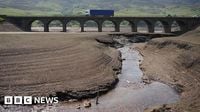
Complicating matters, the Environment Agency has declared a drought in Yorkshire, following the driest spring in over a century. The region has recorded less than half its average rainfall during spring and less than 75% in May. Welsh Water has similarly declared a drought developing zone after the area's driest spring since 1990. The drought declaration means that water supplies are under stress, and authorities may soon request that residents reduce water usage, potentially imposing hosepipe bans if conditions worsen.
Despite the impending storms, temperatures are expected to peak on Friday, reaching highs in the high 20s Celsius, with some areas in eastern England possibly hitting 29 degrees Celsius. This surge in heat and humidity contributes to the formation of thunderstorms, as warm air from continental Europe moves northward. The UK Health Security Agency (UKHSA) has issued yellow heat-health alerts covering the East Midlands, London, the South East, and wider eastern areas from Thursday evening through Sunday morning. These alerts warn of increased health risks, particularly for vulnerable populations such as the elderly and those with pre-existing respiratory or cardiovascular conditions.
As the weekend progresses, a cooler airmass is expected to move in by Sunday, bringing a noticeable drop in temperatures across much of the UK. Showers will linger in parts of the south and east, with patchy rain elsewhere, but no significant impacts are anticipated.
Residents are encouraged to stay informed by following updates from the Met Office through their website, social media channels, and mobile apps. The Met Office's National Severe Weather Warning Service aims to alert the public and emergency services to potential weather hazards, enabling timely preparations and responses.
In summary, the UK faces a challenging weather weekend marked by severe thunderstorms and the paradox of drought conditions in some regions. The combination of intense rainfall, lightning, hail, and gusty winds poses risks of flooding, power outages, and travel disruptions, while the ongoing drought underscores the delicate balance of water resources. As the nation navigates these extremes, vigilance and preparedness remain key to minimizing the impacts of this volatile weather pattern.